- THE SPALDING RESEARCH PROJECT -
Spalding Studies: Ohio Sources
Part Four
Solomon Spalding Documents
1: Misc. Accounts | 2: Misc. Lists | 3: Lake/Wright Docs
web-pages: 1785 letter | 1794 letter | Undated letter | 1811 Forge | Oberlin Ms.
on this page: 1803-12 land docs | c. 1805 Rudd doc | c. 1810 Joiner-Brigham doc
The last page of Spalding's Oberlin manuscript (on the left), together with his undated
draft letter (on the right) -- this undated letter adds 4 pages to the bound volume).
Letter: page 2 (bound first), page 1 (bound second), page 4 (bound last)
Conneaut Witnesses | 1847 Ohio History | 1878 Ashtabula History
|
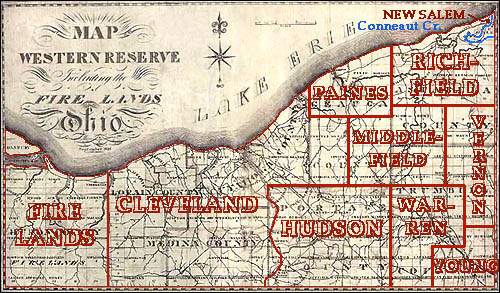
Spalding's Ohio Land Transactions: 1803-1805 Introduction When the State of Connecticut entered the Federal Union following the conclusion of the Revolutionary War it held original claim to lands between 41 and 42 degrees north latitude in the West, in what was to become northeastern Ohio -- from the Pennsylvania border westward past modern Cleveland. This tract of land was known as the Connecticut Western Reserve. Through a series of land concessions and ownership transfers this extensive property was eventually made available for sale to private investors and speculators. The first deeda to these Ohio lands were recorded in the Office of the Secretary of the State of Connecticut. The several title-holders to the lands in the Western Reserve formed a sales organization called the Connecticut Land Company at Hartford, on Sept. 5, 1795. Among these founding investors was Gideon Granger who, in partnership with Oliver Phelps, gained ownership of $80,000 worth of the Ohio lands. (For details on the land division and transfers see pages 9-12 of Williams' 1878 History of Ashtabula County.) On April 28th, 1800 the Federal Government relinquished all claim to the Western Reserve lands, upon the condition that Connecticut recognize a Federal jurisdiction over the area. This opened the way for the Connecticut Land Co. to begin selling properties with clear title in the Western Reserve. The tract was divided up into regular sections and plans were set in motion to have the land surveyed. The Land Co. members received title to their various properties, the exact lots of which were parcled out to them through a draft allotment conducted Jan. 29, 1798. Among those who received property in what was to later become Ashtabula Co. were men such as Caleb Atwater, Eben, David and Fidelio King, Ebenezer King, Jr., Ashhel King, Erastus Granger, Gideon Granger, Gideon Granger Jr., and others. Even before the sub-divided land was offered for sale in individual parcels, pioneer settlers began moving into the Western Reserve in anticipation of future property purchases. Among these first pioneers were Aaron Wright and the Thomas Montgomery family, who arrived at Conneaut Creek in the extreme northeast corner of the Reserve in 1798. The next year Nathan King and others arrived and the first settlement of the Conneaut Creek area of Ohio began in earnest. These early settlers were able to begin recording their property deeds in 1800 at the village of Warren, then the capital town of the Reserve's only county, Trumbull. Among the earliest residents was the numerous King family from New Hampshire who settled along Conneaut Creek in what was to become the southern boundary of Salem Village (see map below). One of this family, Nehemiah King, was the first physician to reside in the Conneaut region. 
The Division of G. Granger and S. Spalding's "Old Section One" (the Northeast Corner of the Connecticut Western Reserve) View graphic of Pennsylvania side of the border Solomon Spalding's Ohio Land Ventures (with those of Gideon Granger and William F. Miller) Old Section One in the "Reserve" By 1803 published maps of the Conneaut lands (as recently surveyed by Amos Spafford) were in circulation on the Western Reserve and among land agents in the East. Land speculation in the northeastern portion of the Reserve was on the increase, with several non-resident owners living in the East transfering portions of their original sections to both individual settlers in Ohio and to other absentee landlords. Matthew Thompson and Reuben Bordwell, the original draft winners for Township 14, Range 1, Section 1, soon transfered their land to the Connecticut speculator William F. Miller. This tract of land, comprising 11 separate lots (see map above) was "Old Section One," the first land surveyed in the northeast corner of the Connecticut Western Reserve. The tract encompassed the mouth of Conneaut Creek and was presumed to have some special value as a potential future harbor on the southern shore of Lake Erie. William F. Miller was an absentee landlord who lived in Windsor, on the Connecticut River, in Hartford County, Connecticut -- he was probably the same "Rev. William F. Miller" who served as pastor of the Windsor Congregational Church between 1794 and 1800. Windsor is in generally the same region where Solomon Spalding was living in 1794, when he wrote his brother Josiah, saying that his employer, Mr. Wiggins, had gone "northward for four months," leaving Solomon to manage the affairs of the business in Lyme (at the mouth of the same river). It is possible that Solomon and Josiah Spalding were acquainted with Mr. Miller of Windsor prior to his obtaining land on the Reserve from Thompson and Bordwell. The land Miller received from Thompson and Bordwell was a rough rectangle of 2,150 acres situated between the eastern bank of Conneaut Creek and the Pennsylvania State line, bordering the southern shore of Lake Erie. Thompeon and Bordwell had originally obtained the property for $2,231.00 in the 1798 draft. Shortly after the turn of the century (apparently after the initial survery of the Reserve was completed in 1799) they sold the land to Miller, probably for a price well above the $1 per acre they had invested in 1798. As for Miller, he was not a pioneer and apparently had no intention of living on his new property. He soon made plans to dispose of these 11 western lots. Solomon Spalding and the Division of Old Section One William F. Miller quickly sold his newly acquired land in Ohio -- probably without ever having seen it. He sold the 11 lots of Township 14, Range 1, Section 1 to another gentleman who was already a landholder on the Reserve, Gideon Granger, Jr. (1767-1822), a Republican politician from Suffield, Hartford Co., Connecticut who had recently been appointed Postmaster General and was then living in Washington D. C. Miller's sale to Granger may have been concluded in Connecticut, but the deed had to be recorded in the county seat of the Western Reserve, then located at Warren, Trumbull Co., Ohio. Granger had a short term need for a business partner in Ohio and his plan in this regard opened the way for his selecting Solomon Spalding (then of New York, previously of Connecticut) as a temporary business partner. According to Josiah Spalding, he and his brother "went into a large speculation in new land in Pennsylvania and Ohio, and after a few years he [Solomon] moved out there... He sold a large amount of land on credit, principally to people in Ohio." What Josiah neglects to say is that Solomon became the junior partner of Gideon Granger, Jr. in about 1802, at least the Ohio part of this "large speculation in new land." Solomon's partnership with Gideon Granger was a brief one and for that reason Josiah may have forgotten it. The details of their business dealings have been lost to history, but on May 30, 1803 Solomon Spalding recorded a deed at Warren, documenting a $2,000 cash transfer to Miller, along Solomon's sizeable mortgage to Miller for the remainder of the purchase price of Old Section One Although the original deed for Old Section One is no longer on file in Warren, later legal foreclosure documents for lots in that tract show that the mortgage between Spalding and Miller was dated and signed in Warren, Ohio on March 30, 1803. Solomon Spalding made the arduous journey from his home in Richfield, Otsego Co., New York to Warren to sign the land and mortgage documents in person. Gideon Granger, Jr. the senior partner and the financier of the purchase, had his attorney sign for him. The lawyer was Calvin Pease, Esq. (1776-1839) of Warren, the brother of Gideon's wife, Mindwell Pease Granger. Calvin and Mindwell were apparently related to the Pease and King families of what became Kingsville and Kelloggsville, Ashtabula Co., Ohio (Mary Sheldon Pease, wife of D. P. Hurlbut, came from there). The brother of Calvin and Mindwell was Seth Pease, once the Surveyor General of the United States, he also served as the original chief surveyor of the Western Reserve. The 11 lots of Section One became the property of Granger and Spalding after May 30, 1803 when the deed was transfered from William F. Miller to Solomon Spalding, but Mr. Granger soon withdrew from the partnership, leaving Spalding holding the mortgage with Mr. Miller. Granger cashed himself out of the business on Sept. 9, 1803, when he (and Spalding) transferred about half of Old Section One to Messrs. Solomon Bond and James Harper, Sr. This intricate sale and swap left Granger considerably richer, in possession of Lot 11, free and clear (see map above), and no longer in business with Solomon Spalding. In the convoluted land deal of Sept. 9, 1803, Granger and Spalding transferred 1008 acres of Old Section One, partly to Solomon Bond of Enfield, Hartford Co. Connecticut and partly to James Harper, Sr. of Ohio. Mr. James Harper, Sr. (1767-1828) was one of the founders of Harpersfield Township in Ashtabula Co. His family came to the Conneaut area (from Harpersfield, Delaware, New York) shortly before Aaron Wright arrived there with the Thomas Montgomery family. James Harper, Sr. was married in 1792 to Sarah Montgomery Harper (1773-1845), the older sister of Aaron's wife, Anna "Hannah" Montgomery Wright (1784-1857). Thus, the New Salem miller, Aaron Wright, was the brother-in-law of James and they both moved to the Conneaut Creek region at about the same time from Harpersfield, Delaware Co., New York (near Oneonta, Otsego Co.) James was born in Cherry Valley, Otsego Co., New York, the same place where Solomon Spalding lived three decades later. While it is possible that Solomon Spalding became acquainted with Harper and Wright back in New York, he certainly became closely involved with these two brothers-in-law during his visit to Ohio in 1803. Aaron Wright was then already operating his grist mill on land apparently previously settled (but not yet deeded to) James Harper, Sr. It seems likely that Spalding, seeing Aaron Wright's water-wheel driven grist mill in successful operation, enquired of Wright and Harper about setting up his own water-wheel driven operation on the same mill race. This idea led Spalding to retain the southwestern 26 acres of Lot 8 (the parcel south of Ridge Road -- see map above) when he worked with Gideon Granger to dispose of about half of Old Section One to Bond and Harper. Solomon Bond ended up owning Lots 1, 5, 7 and the eastern portion of Lot 8. Harper obtained potentially valuable land at the mouth of Conneaut Creek (Lot 3) and land for his brother-in-law's mill (the southwestern 34 acres of Lot 8). The fact that Solomon Spalding was engaged in some sort of land agreement with James Harper, Sr. is confirmed by one other detail of the Sept. 9, 1803 series of land transfers -- he and Harper obtained their property in the eastern end of Lot 8, only after signing a "quit-claim" to their Lot 11, which then becomes the exclusive property of Gideon Granger, Jr. When the deal was completed Harper (and Wright) had the land where the grist mill was located, and Solomon Spalding had property on the same mill race on which to build the water-wheel driven iron forge he planned to establish on Conneaut Creek. Spalding also gained exclusive ownership of Lots 2 (214.00 ac.), 4 (149.75 ac.), 6 (211.00 ac.), 9 (211.50 ac.), and 10 (211.50 ac.), albeit they were subject to seizure by William F. Miller, being property security for Spalding's unpaid mortgage with him. And, in fact, such a foreclosure by Miller did eventually take place -- accounting for Miller's name on four of those same pieces of property on the map. The writers of the 2000 CD-book, Spalding Enigma, agree with the above conclusions, saying (on page 1069): "With respect to lot #8, [James A.] Harper appears to have then split his 60 acre interest with Spalding (possibly Harper 34 acres, Spalding 26 acres, based on 1810 tax receipts) thus providing Spalding with the tract of land upon which the forge was built." The same writers, on the previous page of their book, further interpret Spalding's activities in Ohio at that time, saying: "Spalding also signed this quit-claim [with Harper for Granger, on Sept. 9] in person, thus suggesting that he spent the entire summer of 1803 in Conneaut and that this is when he began construction of the forge which he subsequently (in 1811) contracted with Henry Lake to 'rebuild.'" Their oversimplification of this matter is addressed in various considerations relative to the 1811 Lake-Spalding forge agreement. A transcript of Granger and Spalding's agreement with Harper and Bond follows: RELEASE Solomon Spalding & G. Granger to S. Bond &. J. Harper 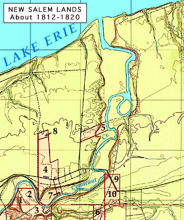
Selected Land Ownership in Salem, 1812-20 (the Northeast Corner of the Connecticut Western Reserve) 1-3 = Nehemiah King, 4 = Aaron Wright, 5 = Nahum Howard 6-8 = Henry Lake, 9 = James A. Harper (later Henry Keyes) 10 = Solomon Spalding (later James Brooks). Solomon Spalding's Land Sales Reputation When Solomon Spalding's nephew Daniel was interviewed in 1888, he had this to say about his Uncle Solomon: "He was a land agent, and my father said he was a scoundrel and used to cheat the people out of their money and property." In fairness to Solomon it should be noted that Daniel was the only person known to have left such a negative report, and that Daniel was a mere boy when his uncle lived in Ohio. Solomon Spalding was indeed a land salesman between 1803 and the fall of 1812 -- he had nearly 1000 acres of property east of Conneaut Creek he needed to sell and a mortgage of approximately $2,500 which he was paying off in periodic installments to William F. Miller in Connecticut. He had to sell off that land, for an average of about $2.50 per acre. He began that business in 1806 and it is likely that he then had less than ten years left on the mortgage -- in short, he had to sell about 100 acres of his own holdings every year, for several years in a row, just to break even on his 1803 purchase. Solomon may have also functioned as a "land agent" for other property owners, collecting a fee for each land transfer he finalized for absentee landlords. But his nephew calls Solomon a "scoundrel" and a "cheat," and those old allegations remain unexplained. Since Spalding's circumstances required him to sell land constantly, just to keep his head above water financially speaking, his sales promotions may have involved more "sharp Yankee trading" than what might have been expected in the hopefully trustworthy dealings of an honest retired clergyman. Solomon Spalding probably never admitted to being in the clergy after he was removed from his position as Headmaster of the Cherry Valley Academy just prior to the year 1800. He had occasionally preached for the Presbyterians there, but the licenses for unordained Congregational and Presbyterian preachers expired in time, and Spalding probably never took the trouble to renew his before moving to Ohio in 1809. While he was living on the Western Reserve, Solomon Spalding simply did not have to live up to the typically high ethics of a Calvinist minister. William H. Leffingwell, who spent time with Spalding in Ohio in 1812 described him in 1885 thusly: "a lawyer by profession... had taught school... had never been a reverend... said he wanted to make some money." Col. Robert Harper, of Harpersfield, reportedly described "Mr. Spalding" as living at "an early day at Conneaut, and had a forge or trip hammer in the valley on the creek... living in a long, low, shanty-like building of boards. In one end was his forge, while in the other he lived with his wife, and kept a kind of grocery store." In short, Solomon Spalding appears to have been living in squalid, poverty-stricken conditions, attempting to make a little money in any way that he could. The modern reader could well imagine that a man living in such a situation, with a heavy mortgage held over his head, might have things that caused his brother John Spalding to tell the family (including young Daniel, his son) that Solomon has not very honest in his land dealings. In fact, John himself had suffered the disappointment of a failed land purchase in the Conneaut region. Whether or not he purchased a farm on the Pennsylvania side of the border from his "lang agent" brother may never be known -- the land records for Erie Co., Pennsylvania were destroyed in a fire in the early 1840s -- but John apparently did experience problems in obtaining a farm in 1810 and was forced to spend part of 1811 on the Ohio side of the border, in New Salem. While there is no firm evidence to show that Solomon Spalding was dishonest in his land dealing, he may have overstated the value of some of the property he was attempting to sell, or resorted to other underhanded means to increase his scanty income. He left Ohio near the end of 1812, begging his creditors not to press their monetary claims against him. He also appears to have left town only a few days or weeks before his major creditor entered a claim against his meager assets in the Ashtabula Co. courts.
continue with more of |
|
Excursus: A Brief Look at Spalding's Pennsylvania Land Sales It will be recalled that Solomon's brother Josiah said that they were engaged in "a large speculation in new land in Pennsylvania and Ohio," selling "a large amount of land on credit, principally to people in Ohio." While Solomon Spalding's Ohio land sales have been described in some detail (see pp. 1067-76 in the 2000 CD-book The Spalding Enigma), his land transactions on the other side of the border remain something of a mystery. Most of these were apparently conducted in Springfield and Conneaut townships, in Erie County, during the first decade of the 1800s. Unfortunately the Erie Co. courthouse burned down in 1841, leaving nearly all the land records in ashes.
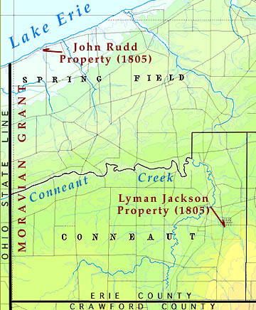
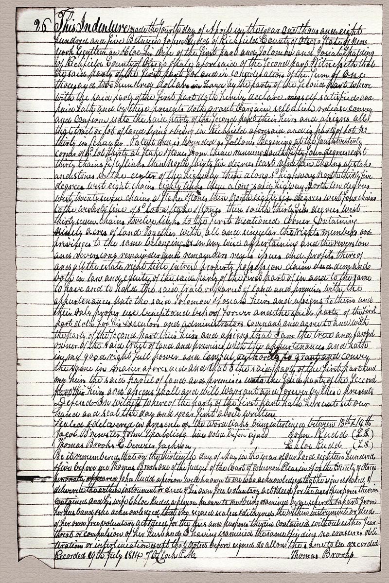
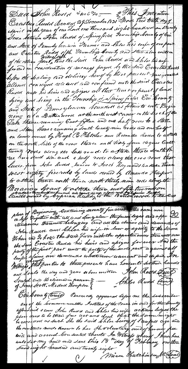
One of Solomon Spalding's early customers for land in Pennsylvania was Mr. Lyman Jackson, an old neighbor of Solomon's from Otsego Co., New York. According to his son, Abner Jackson, writing in 1880, the family moved to Erie Co. in 1805 and founded the town of Jacksons Corners. Abner says: Spaulding contracted for large tracts of land along the shore of Lake Erie, on each side of the State line, in both Pennsylvania and Ohio. My father exchanged with him the farm on which he lived in Otsego County, New York, for land in Erie County, Pa., where the town of Albion now stands, and moved on it A.D. 1805. It was then a dense forest. Shortly after my father moved, Spaulding sold his store in Richfield, and moved to Conneaut, Ashtabula County, Ohio, and built a forge on Conneaut Creek, two miles from Conneaut Harbor and two miles from the State line. In building this he failed, sold out, and... moved to Pittsburgh. Another of Solomon Spalding's Pennsylvania land transactions is slightly better documented. Like the trade with Lyman Jackson, this deal involved Spalding trading land in western Erie Co. for a neighbor's holdings in Otsego Co., New York. The essentials of this trade are recorded in an "Indenture made 4 April 1805 between John and Chloe Rudd (first part) and Solomon and Josiah Spalding (second part) for the sale of a 90-acre tract..." in Richfield, Otsego Co., New York. John Rudd, Sr. died in 1830 and his farm on the southern shore of Lake Erie was divided between his several heirs in 1832. The 1805 indenture document reads as follows: This Indenture made the fourth day of April in the year one thousand eight hundred and five Between John Rudd of Richfield County of Otsego State of New York [exutleman &] C[h]loe his wife of the first part and Solomon and Josiah Spalding of Richfield County of Otsego State aforesaid of the second part Witnesseth that the said party of the first part for and in consideration of the sum of one thousand two hundred dollars in hand by the party of the second part where with the said party of the first part doth hereby declare himself satisfied and paid [h]ath and by these presents doth grant bargain sell [ alien ] release convey and confirm unto the said party of the second part their heirs and assigns all the tract or lot of land lying [ & being ] in Richfield aforesaid and is part of lot no. thirty in [Schuyler's] Patent and is bounded as follows Beginning at the south westerly corner of lot thirty at stake & stones from thence running south fifty four degrees east thirty chains fifty links then north thirty six degrees east nineteen chains at stake and stones in the center of the highway then along sd highway north thirty five degrees east eight chains eighty links then along sd highway north ten degrees west twenty seven chains [a] stake and stones then north eighty six degrees west four chains to the westerly line of sd lot a stake and stones then south thirty six degrees west thirty seven chains twelve links to the first mentioned corner containing ninty acres of land together with all singular the rights members and privileges to the same belonging [ & ] in any wise appertaining and the [reversion] and [reversions] remainder and remainders rents issues and profits thereof and all the estate right title interest property possession claim and demand both in law and equity of the said party of the first part of in and to the same to have and to hold the said tract or parcel of land and premises with the appurtenances unto the said Solomon & Josiah heirs and assigns to them and their only proper use benefit and behoof forever and the said party of the first doth for his executors and administrators covenant and agree to and with the party of the second part their heirs and assigns that I am the true and lawful owner of the said tract of land and premises with the appurtenances and hath in my good right full power and lawful authority to grant and convey the same in manner aforesaid and that I the said party of the first part and my heirs the said parcel of land and premises unto the said party of the second part their heirs and assigns shall and will warrant and forever by these presents De[f[end - In witness whereof the party of the first part hath here unto set our hand and seal the day and year first above written. the word links being interlined between 13th and 14th lines noted before signed Sealed & delivered in presents of Jacob Brewster John Spalding John Rudd (L.S.) Thomas Brooks Ebenezer Jackson Chloe Rudd (L.S.) Be it remembered that on the thirteenth day of May in the year of our Lord eighteen hundred & five before me Thomas Brooks one of the judges of the court of Common Pleas in & for the county of Otsego personally appeared John Rudd a person well known to me who acknowledged that he signed [ & sealed & ] delivered the [ within ] instrument or deed of his own free voluntary act and deed for the uses and purposes therein contained and his wife Chloe Rudd a person known to me and being examined by me separate & apart from her husband & shee acknowledged that she signed sealed and delivered the within instrument or deed of her own free voluntary act and deed for the [uses] and purposes therein contained without either fear threat or compulsion of her husband. I having examined the same and finding no erasures obli[-] teration or interlination except that noted before signed do allow the same to be recorded Recorded [2]9th July 1814 [7] oclock [P.]M. Thomas Brooks Note 1: 1805 John Rudd, Sr. Land Indenture, copy in the Otsego Co., New York Records: "Land Conveyances, 1814-1815, Book S (Grantees)" p. 26. -- The "29th July, 1814" written at the bottom of the page was the recording date for the Rudd's indenture in Otsego Co. New York, At that time a transcription of their copy was written into the official records on page 26 of "Book S". The original document was signed and copies were no doubt given to the Rudds and the Spaldings; these have not survived. The parties mentioned in the land transfer are John Rudd, Sr. (1748-1830), his wife Chloe Hills Rudd (1778-136), Solomon Spalding (1761-1816) and Josiah Spalding (1765-1859), all of whom were living in Richfield Twp., Otsego Co., New York in 1805. The "John Spalding" listed among the witnesses was almost certainly John Spalding (1774-157), the younger brother of Solomon and Josiah, who was also living in Otsego Co. in 1805. Another of the witnesses, Ebenezer Jackson, may have been a relative of Lyman Jackson (1756-1835) who also resided in Otsego Co. near this date. Note 2: It is very likely that the Spalding brothers paid John Rudd, Sr. little or no cash, despite the mention in the document of "the sum of one thousand two hundred dollars in hand." What probably happened is that Solomon and Josiah Spalding gave Rudd their personal note for that amount and that Rudd returned that promissary note to the two brothers as payment for the land, once he took legal possession of his new farm in the extreme northwest corner of Erie Co., Pennsylvania. A young friend of the Rudds, Daniel Tyler, in 1878 spoke of John Rudd, Sr.'s son, Erastus, as being one: "in whose house much of the [Solomon Spalding] romance was formerly written." This statement would agree with Tyler having learned about the said "romance" from John Rudd, Sr.'s son, after the elder Rudd had passed away on Nov. 14, 1830, in Springfield Twp. Mr. & Mrs. Rudd conveyed 75 acres of their farm in tract B of Springfield Twp. to Erastus in about 1830 and Mrs. Rudd had the indenture recorded on Dec. 29, 1831. If the Rudd family home passed to Erastus after the death of his father, that dwelling (within walking distance of Spalding's old home in adjacent New Salem, Ashtabula Co., OH) may indeed have stood on land once owned and frequently visited by Solomon Spalding himself. Note 3: In the 1800 U.S. Census return for Richfield Twp., Otsego Co., Solomon Spalding is shown as being the head of a household which appears to have included his brothers Josiah and John, along with all three of their wives. John Rudd, Sr. and John Rudd, Jr. are also shown as being heads of households residing in Richfield Twp. in 1800. Lyman Jackson and his family are not shown as having lived in Richfield, but the Jackson's family records say that Lyman's son, Abner Jackson, was born in Richfield on Sept. 17, 1795. Abner's sister, Rosanna Jackson (1782-1866) married John Rudd, Jr. (1779-c.1856?) in about 1800 and apparently moved with him from New York to Erie Co. in 1802 and years later to Atlas, Pike Co., Illinois. Probably the Rudd and Jackson families lived close to each other in Otsego Co., New York and some of them traveled together to their new farms in Erie Co., Pennsylvania in 1805. |
|
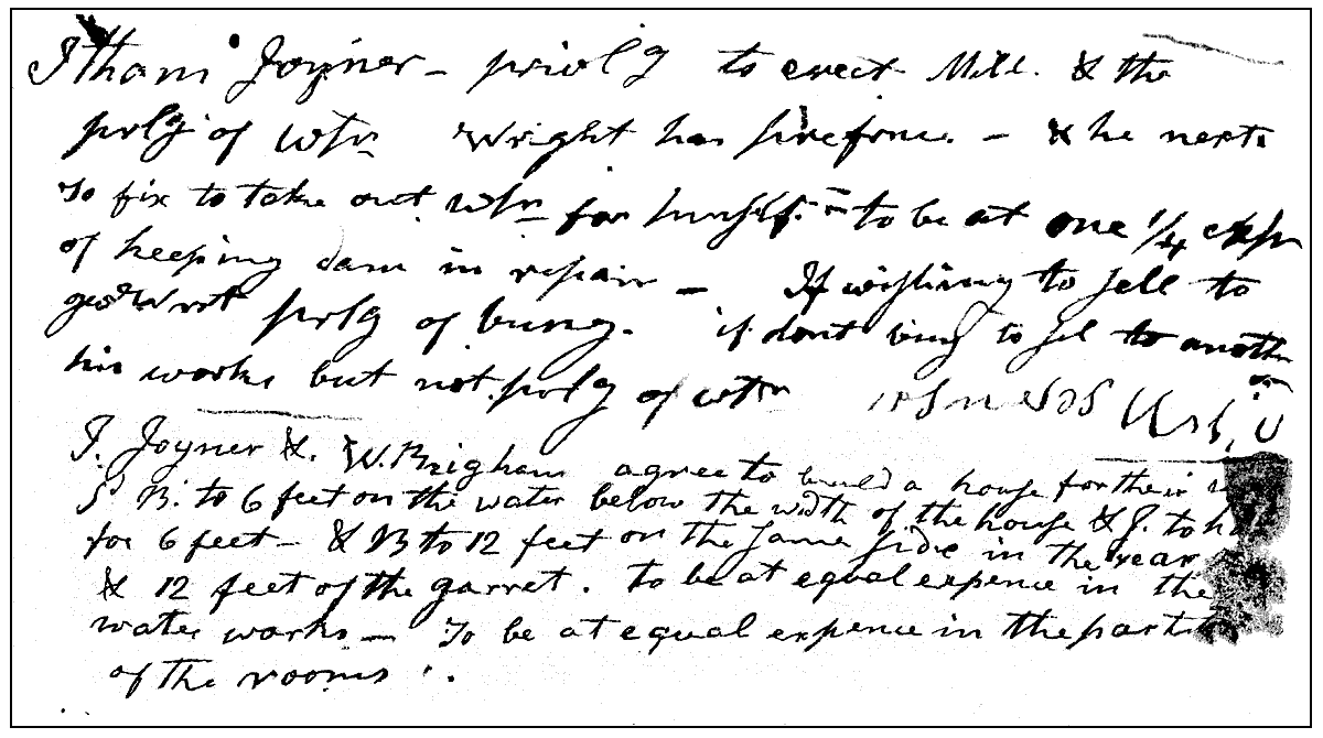
Spalding's Ohio Land Transactions: 1806-12 His Sale of Lot 4 Following his 1803 visit to the Ohio Western Reserve, Solomon Spalding returned to Richfield, Otsego Co., New York, where his brother (and silent partner in western land speculation) Josiah was still running the family store. Apparently Solomon made his second journey to Ohio three years later, when he recorded his first big land sales there on Oct. 21-22, 1806. In the first of these transactions, Solomon disposed of what was probably his potentially most valuable piece of property on Old Section One: this was Lot 6, with 211 acres and a long border fronting on the east bank of Conneaut Creek. Spalding was able to get $500 from the buyer, Josiah Brown -- the only problem was that he had to take payment in grain and stock. Perhaps Solomon did not agree to these terms until he arrived at New Salem and found that Brown was unable to pay him in any other way. Even so, Solomon accepted the offer and Brown's payment was spread over three years, with installments due the first of the year in 1807, 1808 and 1809. The recorded document, from Geauga County Records: Transcribed Records of Geauga County, p. 76; (transcribed June 24, 1837 from Geauga County Record Book A, pp. 191-192), reads as follows: Know ye that I, Solomon Spalding of Ritchfield, County Otsego, State of N.Y. in consideration of $500 received in full satisfaction of Josiah Brown, of County Geauga, State of Ohio, in 14th range of townships in Lot No. 1, being lot no. 1, in said Lot No. 1, as surveyed by Amos Spafford, Esq., and being bounded, north by James Harper's land, east by land owned by Gideon Granger, south by land owned by James Harper, west by Conneaut Creek, containing in all, 149 acres and 3/4 acre. The above mentioned "south by land owned by James Harper" refers to Lot 5, which in 1803 went to Solomon Bond of Connecticut. By 1806 that lot was the property of his Ohio partner, James Harper. As luck would have it, Josiah Brown was either unable to make his full payment for Lot 4 -- or perhaps unwilling to continue his ownership of the property. By 1812 it was again one of Solomon Spalding's real estate possessions and was part of the property William F. Miller foreclosed upon in November of that year. His Sale of Lot 6 On the same day that Spalding recorded his sales agreement with Mr. Brown, he also recorded another, similar transaction with John Montgomery. At this time Spalding's Ohio lots had become part of Geauga County (formed in 1805) and his 1806 land transfers had to be recorded at the new county seat at Chardon. Unfortunately the record of his land sale to Mr. Montgomery was either not transfered to the courthouse at Jefferson when Ashtabula County was formed (on June 7, 1807), or was in some other way lost. The Ashtabula Co. records merely indicate (on page 421, Book 1) that Spalding recorded the sale of his Lot 6 to Mr. Montgomery on Oct. 21, 1806. Lot 6 was among the properties reclaimed by William F. Miller in 1812, so Solomon Spalding may have not realized much reward for its 1806 transfer to Montgomery. His Sale of Lot 2 On the day after Solomon Spalding recorded his sales to Mr. Brown and Montgomery he also recorded the sale of Lot 2 to Hananniah Brooks. This transfer of property was witnessed by Oliver Smith (a friend of Spalding's from Erie Co., Pennsylvania) and by Linus Scovil of New Salem (who also witnessed Spalding's 1811 forge agreement with Henry Lake and Spalding's 1811 agreement with John Dunn). Lot 2 was also among the properties reclaimed by William F. Miller in 1812, so Hananniah Brooks' payment of $428 in cash must have either been refunded or never received by Spalding in full. His Sale of Lot 9 On the same day that Solomon Spalding recorded his sales agreement with Mr. Brooks, he also recorded the sale of Lot 9 to Jonathan Sprague for $300, only part of which Spalding received in cash. Perhaps Sprague was unable to pay off his mortgage to Spalding, for this too was among the lots seized by William F. Miller in 1812 His Sale of Lot 10 On November 1, 1806 Solomon Spalding recorded the sale of his Lot 10 to Elihu Crane. The buyer apparently gave little or nothing as a down payment, but he did promise to give Spalding $510 in grain and livestock over the following three years. Perhaps Crane was unable to live up to thei agreement, for Lot 10, like the others mentioned above, returned to the ownership of William F. Miller in 1812. With his seeming sales of the above mentioned five lots of land in 1806, Solomon Spalding was ready to return to Otsego Co., New York, take care of his obligations there, gather his family (a wife and newly adopted daughter), and relocate to New Salem with his debt to William F. Miller hopefully taken care of. His plan was to go into the iron forging business on his parcel of ground at the far western end of Lot 8 -- his only remaining real property on Conneaut Creek. Unrecorded events delayed his arrival back in Ohio until 1809, but it is probable that he then brought with him some of the equipment and tools needed to set up his intended business. For one reason or another his erection of the forge was left incomplete and it is unlikely that Spalding saw any returns from this business venture until he was able to persuade Henry Lake to become his partner in rebuilding the forge and putting the business into operation in 1811. Spalding's Troubles Begin to Pile Up After returning to New Salem and setting up housekeeping on Conneaut Creek in 1809, Solomon Spalding began to suffer a series if financial and personal setbacks. It seems that between 1806 and 1810 Hananniah Brooks either failed to make full payment for his purchase of Lot 2, or (just as possible) became dissatisfied with what he had received and caused Spalding to reverse the 1809 sale. Whatever the case may have been, Spalding ended up back in possession of the parcel, subdivided the land, and sold the eastern half of it to Amasa Stewart for $321.00 in cash. Spalding recorded the sale at the new Ashtabula Co. courthouse at Jefferson on Sept. 8, 1810. However, recalling that William F. Miller recaimed this Lot from Solomon Spalding's unsold real estate in 1812, it is safe to say that Spalding was unable to make any good use of the sale to Stewart. It is likely that some of his other 1806 customers also began to default in their promised payments during the months that followed. When Solomon and his wife Matilda first arrived in the Conneaut area they did not yet have a house of their own and were forced to move in with Oliver Smith, who lived across the Pennsylvania line, four miles (as the crow flies) east of the forge site. According to Smith's 1833 recollection, the Spaldings spent "six months" (probably from the fall of 1809 until the spring of 1810) with him -- though for some part of that period they may have stayed next door with the family of John Rudd, Sr. During the harsh weather of northern Ohio winter it is doubtful that Solomon Spalding saw much progress in the erection of his iron works or of his new cabin -- the two structures were reportedly constructed on opposite ends of the same wooden building -- though it is uncertain just how close to the pond and mill race the dwelling was built. Conceivably the Spaldings' living quarters may have been laid out at some distance from the mill race and waterwheel, with the forge's trip hammer connected to the waterwheel by a length of gear-drive. He may have begun to erect his waterwheel and forge furnace late in 1809, but it is unlikely that Solomon Spalding had a cabin suitable for permanent occupation on Conneaut Creek until well after the spring thaw of 1810. It must have been at about this time that the would-be iron entrepreneur began to parcel out his 26 acres in the northwestern corner of Lot 8. The content of his undated draft agreement with New Salem residents Itham Joiner and Walter Brigham helps shed some light on this phase of Spalding's activities on Conneaut Creek. The text was published in 1885, but is faulty in a few places. A more reliable transcript reads as follows: Itham Joyner privlg to erect Mill, & the The above agreement (assuming it was ever put into full operation) seems to have granted Messrs. Joiner and Brigham the "privilege" of erecting a mill and dwelling below Spalding's Pond (see map) in trade for their assistance in maintaining the mill pond dam and possibly some other, unspecified consideration. Exactly what Spalding meant by the term "privilege of water" is uncertain. Presumably this had something to do with the two men being allowed to divert water below the mill pond dam into their own mill race -- so long as they left sufficient water flowing downstream for the operation of Aaron Wright's grist mill. As there is no mention in Ashtabula historical records of Joiner and Brigham ever erecting a mill at Spalding's Pond, it is probable that their intended construction never took place and that Solomon was left to bear half of the expenses of maintaining the pond with his neighbor Aaron Wright. Spalding's 1810 Failure at Conneaut Creek As mentioned above, on Sept. 8, 1810 Solomon Spalding resold half of his Lot 2 for $321 to Amasa Stewart. If he had any other substantial income that year, no record of such financial relief has survived. Just the opposite seems to have been the case -- his debts were increasing more rapidly than his ability to pay them. Still, there was a great need for iron implements and utensils on the western frontier and it would seem that Spalding's successful erection of an iron forge on Conneaut Creek during 1810 would have done much to help alleviate his ever growing pecuniary problems. For some unspecified reason Spalding's iron forge never went into commercial operation that year, however. The cause of his 1810 industrial failure at Conneaut Creek may never be known for certain, but one reasonable explanation might be that Solomon Spalding fell victim to some accident that year which necessitated the re-building of his forge and which impinged significantly upon his own ability to carry out the required construction. In a lengthier discussion of this mystery one tentative conclusion is offered: That Spalding (who was not an especially healthy or physically strong man) suffered a disabling hernia before the end of 1810, while trying to set his lagging iron works in operation. It may be significant that Dr. Nahum Howard says in his 1833 statement that he first met Solomon Spalding in Dec. 1810. If Spalding did develop a disabling hernia while building his iron forge, it stands to reason that he would have sought out the local physicians and solicited their medical advice, no matter how little money he had then to pay them. It may be that the forge-builder initially put his physical problems into the hands of Dr. Nehemiah King and that this decision kept him from contacting Dr. Howard professionally until the end of 1810. In any case, Solomon Spalding was ready to share half of his failed iron business with a partner at the beginning of 1811 and that is precisely when Mr. Henry Lake of Buffalo arrived on the scene and invested his time and money in rebuilding Spalding's iron forge. Solomon Spalding must have been especially hard up for cash as the winter of 1810-11 began along the Lake Erie shore. On Jan. 11, 1811, he recorded the sale of a 3/4 acre parcel, no doubt taken from his own homestead, to Mr. John Dunn. The sales document reads as follows: Articles of agreement At some point in 1811 Lake and Spalding finally did get the irons works on Conneaut Creek up and running. That event should have served to lessen Solomon Spalding's financial woes -- but apparently it did very little to put any money in his pocket. Lake's cash payment almost certainly ended up going from his hands, into Spalding's pocket, and from there back into the forge rebuilding effort of 1811. And Spalding only received a share of the sales on the iron he actually produced himself, once the forge was in operation. The various reports of his friends and family, telling of this period, all indicate that he spent a good deal of 1811-12 at home, too ill to carry out his duties at the furnace and trip hammer. Instead, once the rebuilding work was completed, he reportedly wasted his precious resources in employing his working men to excavate a nearby Indian mound. Perhaps his cost in this seemingly trivial work of amateur archaeology amounted to little more than supplying the workers a few extra days of room and board in his house once their construction employment at the forge had ended. The local demand for iron must have been temporarily satiated, however; otherwise he might have set the same men to work at the forge. The opening of the old burial mound produced evidence of a remarkable level of cultural advancement among the prehistoric inhabitants of the Conneaut area. The artifacts found in this excavation and in similar local explorations, included significant quantities of very large human bones, well formed pottery, and other antiquities which reportedly excited the semi-invalid Spalding greatly. Someone in the area (perhaps a young acquaintance of Spalding's) dreamed that a written history of the mound-building Indians, which would answer all questions respecting their long lost civilization, lie buried in the mound. The dream suggested to Spading the notion of writing a fictional history of the extinct Conneaut mound-builders. Exactly when Solomon Spalding began writing this particular "history" remains uncertain -- Oliver Smith reported that Spalding had been engaged in similar literary efforts as early as 1809-10, when he was living at Smith's house -- that "all his leisure hours were occupied in writing a historical novel, founded upon the first settlers of this country." Spalding's 1812 Failure at Conneaut Creek Whether Solomon Spalding began his Ohio story writing in 1809 or in 1811, he was unquestionably preoccupied with this particular pastime when the fateful year of 1812 rolled around. He increasingly attempted to persuade his creditors that the publication and public sales of his fictional history would bring him enough money to pay off his troublesome stack of debts. However, at about the same time that Solomon Spalding was considering placing the final touches on his story of the "first inhabitants" of America, the distressing news of the War of 1812 began to hit the Lake Erie coast. Land sales came to a sudden halt and the market for forged iron became uncertain with the prospect of an imminent British invasion of lakeshore Ohio. Spalding had already been experiencing great difficulties in collecting hard cash from land buyers, but with the prospect of war enveloping the entire Western Reserve, that supposed trickle of payment must have dried up altogether. Solomon Spalding was undoubtedly already far behind on his required periodic mortgage payments to William H. Miller and Solomon's brother Josiah could not furnish enough funds from retail operation in New York to extinguish that debt either. Another of Solomon's brothers, John, moved from New York to Erie Co., Pennsylvania in 1810. Apparently unable to secure a farm there, John moved across the state line and spent part of the year 1811 in New Salem. But John did not have the financial resources to help Solomon out of debt and he soon moved back into Pennsylvania. According to John, he visited his brother Solomon some time during 1812 and found the failed land speculator deep in debt and unable to meet his obligations. Solomon informed his brother that there was still some chance for his fiscal recovery, since he was engaged in writing a book which might be profitable in the near future. It was probably at about this same time that Solomon's other brother from New York, his land speculation partner Josiah, traveled to Ohio to assess the situation there -- locating Solomon and finding him "unwell and somewhat low in spirits." The American Commander at Detroit, General Hull, capitulated to the British on Aug. 15, 1812, leaving lakeshore Ohio open to foreign invasion. Calvin Pease received word at Warren of this calamity on Aug. 25th and passed it on for its first publication in the Pittsburgh press on Aug. 27, 1812. Solomon Spalding and his family at New Salem must have learned of the impending peril by at least the time Calvin Pease received the same information at nearby Warren. Just prior to Hull's surrender, on the night of August 11, 1812, the entire population of New Salem was roused from their beds and sent fleeing to the safety of "Fort Hill," the old Indian earthwork on the southern outskirts of the village. Solomon Spalding likely experienced this event in person, for he wrote of some very similar happenings in the second draft of the story that many years later ended up in the Oberlin College Archives. The time had arrived for Solomon and his family to leave their home on Lake Erie and seek more trustworthy shelter in the hinterland. There was another reason why Solomon Spalding may have chosen this particular period to depart from his residence in Ohio. It seems that William H. Miller had announced his intention to foreclose on Spalding's unpaid mortgage and was making plans to travel to Ashtabula County and seize the poor invalid's possessions. Given this looming menace, the failed forge operator had little choice between his two alternatives: remaining in Ohio and being arrested and sent to debtor's prison, or leaving the state and seeking a better life far away from Miller's New England homeland and reclaimed lands on Conneaut Creek. In leaving New Salem he was able to talk Henry Mr. Lake into furnishing the Spaldings with the means to journey as far afield as Pittsburgh. This probably meant that Mr. Lake gave Solomon some money and helped him hire a wagon and a driver for the move. The expectation was that Solomon would repay Henry the costs after reaching Pittsburgh, where he expected to enter into a profitable publishing venture. The reality was that Solomon Spalding and his family fled Ohio -- perhaps only a few steps ahead of the incensed William H. Miller -- and never returned. Probably the ailing Solomon first set off for his brother John's farm in Crawford Co., Pennsylvania. By the end of the year, no doubt, they had overstayed their welcome with John and had pushed on to an uncertain future in the growing town of Pittsburgh. Mr. Miller traveled to New Salem, arriving there at least a few days before his Nov. 4, 1812 appearance at the Ashtabula courthouse in Jefferson. There he filed suit against the absent Solomon Spalding for the sum of $3, 046.11 -- the total of the unpaid mortgage, with accumulated interest, and perhaps some additional expenses incurred in his hapless dealings with Mr. Spalding. Having found the Spaldings gone and having no opportunity to recover the money from Solomon personally, Miller asked the court to award him the six lots of Old Section One which Solomon still held title to. The court was amenable to Miller's legal action and, on Jan. 8, 1813, issued an order to Quintus F. Atkins, the Ashtabula Co. Sheriff, to sell those particular six lots at auction and forward the proceeds to Mr. Miller. A few days later the Sheriff attempted to auction off the proscribed parcels but could find no buyers willing to pay out anything like three thousand dollars in specie for the entire property. Finally, on March 22, 1813, William H.�Miller himself offered the minimal bid and received back his original ownership of the six lots. On April 20, 1813 Miller had the deed recorded at Jefferson and likely spent the remainder of his life trying to forget he had ever heard the name of Solomon Spalding. Between 1813 and 1820 Miller was able to dispose of all the lots he received in the court judgment. A 1820 land plat for "Salem Gore" shows Lot 2 divided between William Harper and John Harper; Lot 4 divided between James Harper, Sr. and John Brooks, Lot 5 in the possession of John Brooks; Lot 6 owned by Nathaniel Harmon; and Lots 7, 9, and 10 in the hands of Henry Keyes. Lot 1 and the eastern part of Lot 8 were owned by Samuel Hinkley. What became of Spalding's homestead in Lot 8, his cabin, forge, dam and pond remains unclear. By 1820 the southwestern part of Lot 8 had passed from James Harper to James Brooks. The northwestern part of Lot 8 had come under the ownership of Henry Keyes. Presumably Solomon disposed of his 26 acres to Henry Lake, James Harper, Sr., or some other citizen of Ashtabula Co. From that middleman the parcel passed to James Brooks. Various historical accounts say that Elias Keyes obtained the old Spalding-Lake forge some time after his 1814 -- the year Elias moved to New Salem -- and that he operated the iron works there for an indefinite period of time. By the next decade all mention and trace of Spalding's forge disappears from the record -- until the historians of a later day compiled the pioneers' recollections and gave the ephemeral iron works a few short mentions in their accounts of Old Ashtabula.
1813 Affidavit
Received for record 24 March, 1813 -- Recorded April 20, 1813 -- James Warner for James A. Harper, Recorder for Ashtabula County, State of Ohio. |
Go to top of this page
This web page and the episode links (below) are still under construction
Spalding Saga:
intro | 01 | 02 | 03 | 04 | 05 | 06 | 07 | 08 | 09 | 10 | 11 | 12
Spalding Studies "Research" | Spalding Research Project | Special Collections
"Home" | Bookshelf | Mormon Classics | Newspapers | History Vault
Last Revised: June 16, 2002