- THE SPALDING RESEARCH PROJECT -
|
William W. Williams History of Astabula Co., Ohio Philadelphia, Williams Bros., 1878 |
|
See also: "Conneaut Witnesses" | Ashtabula Spalding Sources | 1873 news articles
|
1798. HISTORY OF ASHTABULA COUNTY, O H I O, WITH Illustrations and Biographical Sketches OF ITS PIONEERS AND MOST PROMINENT MEN. _____________ PHILADELPHIA WILLIAMS BROTHERS. 1878. |
|
[ 5 ]
HISTORICAL AND DESCRIPTIVE. HISTORY OF ASHTABULA COUNTY. CHAPTER PAGE INTRODUCTORY . . . 7 I. -- The Progress of Discovery . . . . 8 II. -- The Connecticut Western Reserve . . . 9 III. -- The Connecticut Land Company . . . 10 IV. -- The Geography of the County . . . . 14 V. -- The Geology and Topography of the County . . 15 VI. -- The Mound-Builders . . . . . 16 VII. -- The Indians . . . . . . . . 20 VII. -- The Parent State . . . . . . 24 IX. -- Pioneer Settlements . . . . . . 24 X. -- Means of Communication . . . 21 XI. -- Civil Organieation . . . 28 XII. -- Social Life in Early Times . . . . 31 XIII. -- Connection with the Anti-Slavery Movement . 33 XIV. -- Religious and Educational . . . . 35 XV. -- The Press . . . 38 XVI. -- Societies . . . 41 XVII. -- The Ashtabula Railway Disaster . . . 115 XVIII. -- Statistics . . . 48 XIX. -- The Military History of the County . . 49 Rostcr of Soldiers from Ashtabula County: War of 1812 . . 57 Roster of Soldiers from Ashtabula County: War of the Rebellion 58 HISTORIES OP THE TOWNSHIPS. Andover . . . . . 215 Ashtabula . . . . 130 Austinburg . . . 185 Cherry Valley . . 236 Colebrook . . . . . 211 Conneaut . . . . . 154 Denmark . . . . . 213 Dorset . . . . . . . . 209 Geneva . . . . . . . 173 Harpersfield . . . 169 Hartsgrove . . . . .254 Jefferson . . . . . . . . 146 Kingsville . . . . . . 204 Lenox . . . . . . . . . 222 Monroe . . . . . . . 200 Morgan . . . . . . . 194 New Lyme . . . . 225 Orwell . . . . . . . 231 Pierpont . . . . . . 234 Plymouth. . . . . 221 Richmcnd . . . 227 Rome . . . . . . . 215 Saybrook . . . . . 153 Sheffield . . . . . .238 Trumbull. . . . . 228 Wayne . . . . . . . . 243 Williamsfield . . 241 Windsor . . . . . . . 250 ERRATA. . . . . . . 256 BIOGRAPHICAL DEPARTMENT. PAGE Allen, Hon. D. C. . . . . . . . . . 166 Andrews, Benoni . . . . . . . . . 168 Atkins, Josiah. . . . . . . . . . . . . 225 Atkins, Hon. Q. F. . . . . . . . . . 113 Austin, Hon. Eliphalet . . . . . 114 Badger, Rev. Joseph H. . . . . . 86 Bartholomew, Rev. J. B. . . . 193 Beals, A. E. . . . . . . . . . . . . . . . 238 Bedell, Henry . . . . . . . . . . . . . 181 Betts, Hon. E. J. . . . . . . . . . . . 125 Blakeslee, Joel. . . . . . facing 212 Booth, Charles . . . . . . . . . . . . 92 Booth, Philo . . . . . . . . . . . . . . 143 Brown, John . . . . . . . . . . . . . 230 Burington, N. . . . , . . . . . . . . 167 Burrows, S. S., M.D. . . . . . . . 120 Cadwell, Hon. Darius . . . . . . 93 Castle, Amasa, Jr. . . . . . . . . . 143 Caswell, N. S. . . . . . . . . . . . . 182 Churchill, John . . . . . . . . . . 230 Clark,Wesley . . . . . . . . . . . . 238 Coleman, Elijah, M.D. . . . . 119 Coleman, Nethaniel. . . . . . 248 Cook, S. H. . . . . . . . . . . . . . .126 Cowles, Alfred . . . . . . . . . . . 103 Cowles, Miss Betsey M. . . . 100 Cowles, Miss Cornelia R. . . 101 Cowles, Edwin . . . . . . . . . . . 97 Cowles, E. W., M.D. . . . . . . . 99 Cowles, G. H., D.D. . . . . . . . . 93 Cowles, Giles H. . . . . . . . . . . 192 Cowles, Joseph B. . . . . . . . . . . 192 Cowles, Capt. Lysander M. . .193 Cowlee, Hon. Samuel . . . . . 102 Crosby, D.L. . . . . . . . . . . . . . . 126 Crosby, Elijah . . . . . . . . . . . . 220 Crosby, Levi . . . . . . . . . . . . . 220 Crowell, W. H. . . . . . . . . . . 125 Crowell, William, Sr. . . . . 220 Curtiss, C. E. . . . . . . . . . . . . 208 Dibble, A.C. . . . . . . . . . . . . .167 Farnham, Elisha . . . . . . . . .167 Farrington, S. H., M.D. . . 120 Fassett, Hon. Henry. . . . . 104 Fifield, A. K., M.D. . . . . . 121 Fifield, Greenleaf, M.D. . 127 Fitch, E. H. . . . . . . . . . . . . . 92 Fitch, Hon. O. H. . . . . . . . . 90 Fobes, Ferdinand . . . . . . 249 Fobes, Henry C. . . . . . . . . . . . . .180 Fobes, O. P. . . . . . . . . . . . . . . . . 249 Fobes, Simon . . . . . . . . . . . . . . 249 Follett, N. . . . . . . . . . . . . . . . . . 235 Gaylord, Harvey R. . . . . . . . . . 118 Gaylord, Maj. Levi . . . . . . . . . .116 Gibson, Thomes . . . . . . . . . . . 167 Giddings, Hon. Joshua R. . . . . 72 Giddings, William . . . . . . . . . 242 Gist, D. D., M.D. . between 148, 149 Hall, Rev. John . . . . . . . . . . . . 128 Hammond, Edward . . . . . . . . 208 Hardy, H. F. . . . . . . . . . . . . . . . 203 Harmon, Austin . . . . . . . . . . . 217 Harmon, Edward . . . . . . . . . . 218 Hart, Elijah . . . . . . . . . . . . . . . 180 Holbrook, S. G;., M.D. . . . . . . 126 Howard, A. W. . . . . . . . . . . . . 193 Howells, J. A. . . . . . . . . . . . . . 121 Howells, Hon. W. C. . . . . . . 103 Howland, Hon. W. P. . . . . . . . 91 Hubbard, Henry . . . . . . . . . . 124 Hubbsrd, J. C., M.D. . . . . . . . 119 Hubbard, Hon. Matthew . . 123 Hubbard, William . . . . . . . . 124 Hurlburt, E. G. . . . . . . . . . . . 256 Jones, Linus H. . . . . . . . . . .. 246 Jones, Samuel, Sr. . . , . . . . . 246 Jones, Samuel, Jr. . . . . . . . . 246 Kellogg, Hon. Abner . . . . . 106 Kellogg;, Amos . . . . . . . . . . 115 Kellogg, L. D., M.D. . . . . . . .120 Kellogg, Martin . . . . . . . . . 115 Kellogg, Paulina . . . . . . . . . 116 Kellogg, Hon. William . . . 107 Kelley, Dr. D. E. . . . . . . . . . . 145 Keyes, Gen. Henry . . . . . . . 168 Kiddle, John . . . . , . . . . . . . 249 King, Mrs. Lydia . . . . . . . . 167 Kingsley, M., M.D.. . facing 208 Lattimer, V. D. . . . . . . . . . . 198 Lee, Ferdinand . . . . . . . . . . 123 Leonard, Hon. E. B. . . . . . . 125 Lindsley, H. . . . . . . . . . . . . . 237 Maltby, Nelson . . . . . . . . . . 181 Mason, E. F. . . . . . . . . . . . . . 125 Mills, Deacon Joseph . . . . . 194 Morse, Rev. Elias . . . . . . . . 242 Northway, Hon. S. A. . . . . . 92 Parker, Luther. . . . . . . . . . 181 Peck, E. O. . . . . . . . . . . . . . 228 Peck, S. W. . . . . . . . . . . . . 119 Pinney, W. K. . . . . . . . . . 203 Poole, Calvin, Jr. . . . . . . 168 Randall, B. C. . , . facing 199 Ranney, Hen. Rufus P. . . 85 Ransom, Miss C. L. . . . . . 111 Raymond, D. W., M.D. . .166 Reed, James . . . . . . . . . . . 122 Rieg, J. P. . . . . . . . . . . . . . 123 Robertson, J. P. . . . . . . . . 146 Salisbury, Capt. O. . . . . 166 Schramling, Alvin . . . . 235 SeCheverell, Col. G. H. . 172 SeCheverell, Dr. J. H. . . 172 Simonds, C. S. . . . . . . . . .105 Simonds, W. T. . . . . . . 185 Smith, Hall . . . . . . . . . . 145 Smith, L. W. . . . . . . . . . . 145 Smith, Plin . . . . . . . . . . 168 Spelman, Dr. Luther . . 246 Spencer, H. A. . . . . . . . . 110 Spencer, H. C. . . . . . . . . 110 Spencer, L. P. . . . . . . . . . 110 Spencer, Platt Rogers . . 107 Spencer, Platt R., Jr. . . . 119 Spencer, R. C. . . . . . . . . . 111 Spencer, W. P. . . . . . . . . 122 Spring, R. . . between 176, 177 Stiles, Captain A. W. . . 126 Stone, James . . . . . . . . . 199 Talcott, Charles . . . . . . . 180 Talcott, Henry . . . . . . . . 153 Thorp, Hon. Freeman . . 119 Tinker, Charles . between 176, 177 Wade, Hon. B. F. . . . . . . . . 67 Wade, Edward . . . . . . . . . . 84 Warner, Hon. Jonathan . . 115 Watroust John B. . . . . . . . . 144 Webster, E. M., M.D. . . . . 127 Webster, H. H., M.D. . . . . 127 Wilder, Hon. Horace . . . . 89 Willard, George . . . . . . . . 144 Woodbury, Hon. H. B. . . . 91 Wright, M. W. . . . . . . . . 208 Wyman, Rev. O. T. . . . . . . 169 Young, Thaddeus S.. . . . . . 125 |
|
ILLUSTRATIONS. ______ PAGE
Court-House (Frontispiece) . . . . facing title page
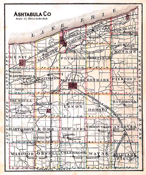
Map of Ashtabula County . . . . . . facing 7
County Jail and Recorder's Office, with portraits of
E. O. Peck, E. C. Hurlburt, and W. T. Simonds . . . . . . . . . . . facing 31
County Infirmary Buildings, with portraits of
Edward Hammond, C. E. Curtiss, and M. W. Follett . . . . . . facing 48
Ashtabula Disaster -- Ruins of the Bridge . . . " 45
Residence of Hon. B. F. Wade . . . . . . . . . . . . . " 70
Portrait of Hon. B. F. Wade (steel) . . . . . . . . . " 67
" Joshua R. Giddings . . . . . . . . . . . . " 72
" Edward Wade . . . . . . . . . . . . . . . . . " 84
" Rufus P. Ranney . . . . . . . . . . . . . . " 86
" Rev. Joseph Badger . . . . . . . . . . . . " 86
" Hon. O. H. Fitch . . . . . . . . . . . . . . . " 90
" Horace Wilder . . . . . . . . . . . . . . . . " 89
" Abner Kellogg . . . . . . . . . . . . . . . . . .106
Portraits of Group of Attorneys:
Hon. W. P. Howland, Hon. H. B. Woodbury, Hen. Edward H. Fitch,
Hon. S. A. Northway, and Charles Booth . . . . facing 91
Portrait of Hon. Darius Cadwell . . . . . . . . . . . 93
" C. S. Simonds . . . . . . . . . . . . . . . . . 105
" Edwin Cowles (steel) . . . . . . . facing 99
" E. W. Cowles, M.D. (steel) . . . . . . . " 99
" Miss Betsey Cowles (steel) . . . . . . . " 101
" Miss Cornelia Cowles (steel) . . . . . " 101
Portraits of Physicians' Group:
Dr. John C. Hubbard, Dr. A. K. Fifeld, Dr. L. D. Kellogg, Dr. S. S. Burrows,
Dr. Elijah Coleman, and Dr. S. H. Farrington . . . . facing 121
Portatit of Hon. William Kellogg . . . . . . . . . . 107
" W. C. Howells . . . . . . . . . . . . . . . . . 103
" Henry Fassett . . . . . . . . . . . . . . . . . 104
Portraits of Editors' Group:
J. A. Howells, James Reed, Warren P. Spencer, J. P. Rieg, and
Ferdinand Lee . . . . facing 123
Portrait of Hon. Q. F. Atkins . . . . . . . . . . . . . 113
" Harvey R. Gaylord . . . . . . . . . . . . 118
Portraits of Physicians' Group:
Dr. S. G. Holbrook, Dr. H. H. Webster, Dr. Greenleaf Fifield,
Dr. E. M. Webster . . . . facing 121
Portrait of Hon. FreemanThorp . . . . . . . . . . 119
Portraits of Spencer Group:
Prof. Platt R. Spencer, R. C. Spencer, H. C. Spencer, H. A. Spencer,
Lyman P. Spencer, and Platt R. Spencer, Jr. . . . . facing 108
Portraita of the Hubbard Group:
Hon. Matthew Hubbard, William Hubbard, and Henry Hubbard . . . . facing 124
Portraits of the County Officers' group:
Hon. E. J. Betts, W. H. Crowell, E. P. Mason, Hon. E. B. Leonard,
D. L. Crosby, A. W. Stiles, T. S. Young, and S. H. Cook . . . . facing 125
ANDOVER.
Residence of Austin Harmon . . . . . . . . . . . . facing 217
" C. Stillman, with portraits . . . . . . . . " 215
" and mills of C. H. Bitts . . . . . . . . . . . " 216
ASHTABULA.
Portrait of Philo Booth . . . . . . . . . . . . . . . . . . . . 143
" Dr. D. E. Kelley . . . . . . . . . . . . . . . . . 145
Residence of George Willard, and interior and exterior Views of Store,
with portraits . . . . . . . . . . . . . . . . . . . . . between 144, 145
Residence of John P. Robertson . . . . . . . . . facing 138
" M. G. Dick . . . . . . . . . . . . . . . . . . . . " 130
" Wm. M. Eames . . . . . . . . . . . . . . . . . 130
" James P. Jennings . . . . . . . . . . . . . ." 135
Pheonix Iron-Works . . . . . . . . . . . . . . . . . . . . . . . . . 140
Exterior Views of Store and Opera-House of L. W. Smith & Son . . facing 142
Interior View of Webb & Son's Store . . . " 142
Carriage-Works of F. D. Fickinger, with portrait . . . between 140, 141
Carriage-Works of Thorp & Pfaff . . . . . . . . . facing 138
Flouring Mills of Semour and Son . . . . . . . . . . . . " 138
AUSTINBURG.
Portrait of Deacon Joseph Mills . . . . . . . . facing 188
Residence of A. W. Howard, with portraits . . " 193
Residence of the late Rev. C. H. Cowles . . . . . " 188
Church at Austinburg . . . . . . . . . . . . . . . . . . . . . . 188
CHERRY VALLEY.
Portrait of Joel Rice (Williamsfield Group) . facing 242
Residence of Wesley Clark, with portraits . . . . . . . . . 236
" A. E. Beals, " " . . . . . . . . . . . . . . . . . . . " 238
" H. Lindsley, " " . . . . . . . . . . . . . . . . . . . " 231
COLEBROOK.
Portraite of Mr. and Mrs. Joel Blakeslee . . . . facing 212
CONNEAUT.
Portrait of Hon. D. C. Allen . . . . . . . . . . . between 166, 167
" General Henry Keyes . . . . . . . . . . . . " 166, 167
Portraits of Mr. and Mrs. Plin Smith . . . . . . . . " 166, 167
Portrait of Dr. D. W. Raymond . . . . . . . . . . . . . ." 166, 167
" Nelson Burington . . . . . . . . . . . . . . . " 166, 167
" A. C. Dibble . . . . . . . . . . . . . . . . . . " 166, 167
" Aunt Lydia King . . . . . . . . . . . . . . . . " 166, 167
Portraits of Mr. and Mrs. Benoni Andrews . . . " 166, 167
Christian Church, with portraits of Rev. O.T. and Mrs. O.T. Wyman facing 162
Residence of J. P. Rieg . . . . . . . . . . . . . . . . . . . . . " 162
" S. J. Smith . . . . . . . . . . . . . . . . . . . . " 156
Business Block of S. J. Smith. . . . . . . . . . . . . . . ." 156
Town Hall . . . . . . . . . . . . . . . . . . . . . . . . . . . . . . . " 154
Residence of Thomas Oibson, with portraits . " 160
" Captain Salisbury, " between 158, 159
" Calvin Poole, . . . . . . . . . . . " " 158, 159
Mill Property of Benton, Ayers $ Cushing . . . . . 165
Portrait of E. Farnham . . . . . . . . . . . . . . . . . facing 203
DENMARK.
Residence of J. C. Andrews . . . . . . . . . . . . facing 213
GENEVA.
Portrait of R. Spring. . . . . . . . . . . . . . between 176, 177
" Charles Tinker . . . . . . . . . . . . . . " 176, 177
Residence of Charles Talcott, and exterior & interior Views of Store " 178, 179
Residence of S. H. Munger . . . . . . . . . . . . . . " 174, 175
" N. S. Caswell, with portraits facing 182
" N. H. Dickerman . . . . . . . . . . . . . . " 172
" R. Spring . . . . . . . . . . between 176, 177
" H. W. Forman . . . . . . . . . . . . facing 178
" Henry C. Fobes . . . . . . between 180, 181
Portraits of H. C. Fobes, Electa Fobes, Sanford L. Fobes, Flora H. Fobes,
David A. and Fanny C.Fish . . . . . . . . . . . . . . . . . . . . " 180, 181
Public SchoolBuilding . . . . . . . . . . . . . . . . . . " 174, 175
Hotel of Thomas B. Tuller . . . . . . . . . . . . . . facing 173
Residence of Luther Parker . . . . . . . . . . . . . . . . . . . 176
" Henry Bedell, with portraits between 180, 181
" Nelson Maltby, " . . . . . . . . . . . . . . . . " 180, 181
" Samuel W. Peck, " . . . . . . . . . . . . . . facing 179
" Robert Woodruff, " . . . . . . . . . . . . . . . " 177
" Cynthia Hart, " . . . . . . . . . . . . . . . . . . . " 175
Geneva Congregational Church . . . . . . . . . . . . . . . . . " 183
HARPERSFIELD.
Portraits of Dr. J. H. SeCheverell and wife . . . . . facing 171
" Col. G. H. SeCheverell and wife . . . . . . . " 171
Residence of M. Wharram . . . . . . . . . . . . . . . . . . . . . . " 172
JEFFERSON.
Portrait of Dr. D. D. Gist . . . . . . . . . . . . . . between 148, 149
Residence of H. P. Wade . . . . . . . . . . . . . . . . . . . facing 146
Property of Henry Talcott, with portraits . . . . . . . . . " 153
Jefferson Educational Institute . . . . . . . . . . . . . . . . . . " 150
Residence of E. L. Mullen . . . . . . . . . . . . between 148, 149
" John Watters . . . . . . . . . . . . . . . . . ." 148, 149
KINGSVILLE.
Portrait of Dr. M. Kingsley . . . . . . . . . . . . . . . . . facing 208
Residence of Dr. E. M. Webster (Frontispiece) . . . . " 204
Kingsville Cemetery . . . . . . . . . . . . . . . . . between 206, 207
Residence of John Holmes . . . . . . . . . . . . . . . . . . facing 208
" H. P. Newton . . . . . . . . . . . . . . between 204, 205
" Stephen Sabin . . . . . . . . . . . . . . . . . " 204, 205
" J. F. Blair . . . . . . . . . . . . . . . . . . facing 207
" Charles H. Crater . . . . . . . . . . . . . . . . . " 208
MONROE.
Portrait of H. F. Hardy . . . . . . . . . . . . . . . . . . facing 203
" William K. Pinney . . . . . . . . . . . . . . . " 203
Residence of Hiram Griggs . . . . . . . . . . . . . . . . . . " 192
MORGAN.
Portrait of B. C. Randall . . . . . . . . . . . . . . . . . facing 199
" Alonzo Moses . . . . . . . . . . . . . . . . . . . . . . 199
Residence of the late James Stone, with portraits, facing 194
" E. O. Miller . . . . . . . . . . . . . . . . . . . . . . 196
Stores of Lattimer & Thompson . . . . . . . . . . . . . . . . 196
PIERPONT.
Residence of Alvin Schramling, with portraits . facing 234
ROME.
Residences of L. and G. H. Crosby, with portraits, facing 218
Residence of Elijah Crosby . . . . . . . . . . . . . . . . . . . . . " 220
SAYBROOK.
Residence of Isaac Brooks . . . . . . . . . . . . . . . . . . facing 183
" O. H. Calloway . . . . . . . . . . . . . . . . . . . " 183
" D. H. Kelley . . . . . . . . . . . . . . . . . . . . " 184
TRUMBULL.
Residence of John and Eleanor Churchill facing 196
" John Brown, with portrait . . . . . . . " 228
WAYNE.
Portrait of Rev. E. T. Woodruff . . . . . between 248, 249
" Dr. Spelman . . . . . . . . . . . . . . . . . . facing 245
" Nathaniel Coleman . . . . . . . . . . . . . . . " 245
" Mrs. N. Coleman . . . . . . . . . . . . . . . . . . " 245
" Samuel Jones, Sr. . . . . . . . between 246, 247
" Linus H. Jones . . . . . . . . . . . . . . . . . " 246, 247
" Samuel Jones, Jr. . . . . . . . . . . . . . . . " 246, 247
" Anson Jones . . . . . . . . . . . . . . . . . . . . . 246, 247
Residence of O. P. Fobes, with portraits of Simon and Berdinand " 248, 249
Residence of Rollin L. Jones, with portraits " 246, 247
" Wm. Kiddle . . . . . . . . . . . . . . . . facing 243
WILLIAMSFIELD.
Portraits of Mr. and Mrs. William Giddings . . . facing 242
" Rev. Elias and Mrs. Abiah Morse . . . . . . " 242
WINDSOR.
Residence of F. R. Smith . . . . . . . . . . . . . . . facing 159
" S. C. Wilson . . . . . . . . . . . . . . . . . . " 251
" Prof. E. Hamilton . . . . between 252, 253
" Thompson Higley . . . . . . . . . " 252, 253
|
|
|
12 HISTORY OF ASHTABULA COUNTY, OHIO. SURVEY OF THE WESTERN RESERVE. The title having been perfected, the company made preparations to survey the portion of the Reserve Iying east of the Cuyahoga. In the early part of May, 1796, the company fitted out an expedition for this purpose, of which Moses Cleaveland was the leader of a company, -- all told of about forty men, -- five of them surveyors, one a physician, and the rest chain-men and axe-men.By previous arrangement they met at Schenectady, New York, at which point they commenced their journey, ascending the Mohawk in four fiat-bottomed boats, proceeding by the way of Oswego, Niagara, and Queenstown to Buffalo, reaching the soil of the Reserve on the 4th of July. ARRIVAL OF THE SURVEYORS. The records of the Ashtabula Historical and Philosophical Society contain an interesting narrative made by Judge Stow of the journey of this surveying party, and from this we gather what follows in relation to the expedition.At the time the party commenced its journey, Fort Oswego, which they were compelled to pass, was garrisoned by the British. They anticipated difficulty in being able to get beyond the fort. At Fort Stanwix, however, they had the good fortune to be overtaken by Captain Cozzens, who had been sent by the British minister, Mr. Bond, with open dispatches to all his majesty's officers and subjects, announcing the ratification by both governments of Jay's Treaty, and that the navigation of the lakes should henceforth be free to all American vessels. They now anticipated no trouble. Captain Cozzens took passage on board Judge Stow's boat, and they ascended Wood creek toward Lake Ontario. When arrived at Oswego, however, permission to pass the fort was denied on the ground that his instructions were positive, and, without the sanction of his superior officer, then at Niagara, he was powerless to grant the request. Mr. Stow's instructions from the Land Company were not in any event to attempt to run by the fort; but if permission were withheld, to lie in wait until further orders from the company should be received. But the climate was unhealthy; the soldiers in the garrison were many of them sick, and some of them dying; time was precious, and the anxiety to reach the Reserve was great. After much deliberation, it was almost the unanimous voice of the party to attempt the passage. The boats were floated down to within four miles of the fort, when they were hauled into a small bay and secreted among the bushes. One of the boats was then relieved of the greater part of its cargo, manned with double oars, and, with the agent (Mr. Stow) on board, moved down to the fort. The British officer in command of the fort evidently supposed that the boat was on its way to Fort Niagara to obtain the consent of the officer in command at that point to make the passage, and the crew were not disturbed. The garrison was thrown off its guard by this stratagem, and at dead of night the other boats passed the fort unobserved, and joined their companions on the waters of Lake Ontario. The following incident of the voyage will be of interest: "The first boat had proceeded as far as to Sodus, where the little fleet intended to make a harbor. A sudden storm arose, and overtook the boats before they could reach Sodus. Night had come on, and the darkness was intense; the storm became more and more violent, and the situation was one of imminent peril. Beacon-fires were built by the crew of the boat which had landed, but it was impossible for the rest of the boats to make the harbor. The situation of the agent at this moment was intensely painful. His companions were in a perilous situation, and it was out of his power to afford them any relief. They were but a short distance from a dangerous shore, and the next billow might dash their little barks in pieces. Besides, he had assumed the responsibility of running by the fort, and, although successful in that attempt, yet if the boats were cast away or lost, the whole responsibility of the catastrophe would rest upon him. In this state of suspense and alarm, a man from one of the boats came running from the beach with the intelligence that all was lost. "No anxiety could be greater or suffering more intense than that of the men on shore. They ran up and down the beach to see if it were not possible to render some assistance or gain some tidings from their companions. They found thrown upon the shore a gun and oar, which they recognized as belonging to Captain Beard, who was in charge of one of the boats. This increased their alarm. The next moment, however, they met Captain Beard himself, and anxiously asked if all were lost. He replied that nothing was lost but a gun and an oar! No lives were lost. The boats sustained much injury, and one was so badly damaged it could not be repaired and was abandoned." Without more adventure worthy of note Mr. Stow and his comrades reached the mouth of Conneaut creek in the early part of July, 1796. The names of this surveying-party, a company of fifty-two persons, all told, are as follows: Moses Cleaveland, the Land Company's agent; Joshua Stow, commissary; Augustus Porter, principal surveyor; Seth Pease, Moses Warren, Amos Spafford, Milton Holley, and Richard M. Stoddard, surveyors; Theodore Shepard, physician; Joseph Tinker, principal boatman; Joseph McIntyre, George Proudfoot, Francis Gray, Samuel Forbes, Elijah Gunn, wife, and child, Amos Sawtel, Samuel Hungerford, Amos Barber, Stephen Benton, Amzi Atwater, Asa Mason, Michael ()offin, Samuel Davenport, Samuel Agnew, Shadrach Benham, William B. Hall, Elisha Ayers, George Gooding, Norman Wilcox, Thomas Harris, Timothy Dunham, Wareham Shepard, David Beard, John Briant, Titus V. Munson, Joseph Landon, Olney F. Rice, James Hamilton, John Lock, James Halket, Job V. Stiles and wife, Charles Parker, Ezekiel Morley, Nathaniel Doan, Luke Hanchet, Samuel Barnes, Daniel Shulay, and Stephen Burbank. It is a noteworthy coincidence that this advance-guard of the army of civilization that was soon to people the territorial limits of what is now known as " Old Ashtabula," first touched her soil on the anniversary of America's independence. Thus in this signal manner did a new colony, destined to play so important a part in the future of the nation, begin its existence on the same day of the same month in which the nation itself began to exist. Nor were these sons of Revolutionary fathers oblivious of the day which not only commemorates the birth of their country's freedom, but should henceforth be to them and their posterity the anniversary of the day on which their pilgrimage ended, and on which began their labors, toils, and sufferings for the establishment in the wilderness of Ohio of homes for themselves and their children. Animated with emotions appropriate to the occasion, these Pilgrim Fathers of the Western Reserve celebrated the day with such rude demonstrations of patriotic devotion and joy as they were able to invent. They gathered together in groups on the eastern bank of the creek now known as the Conneaut; they pledged fidelity to their country in liquid dipped from the pure waters of the lake; they discharged from two or three fowling-pieces the national salute; they ate, drank, and were merry, blessing the land which many of them had assisted in delivering from British oppression; and they may have indulged in glowing predictions as to the future greatness and glory of the colonies they were about to plant. Could one of their number who shared their fancies, but who lived to see no part of them realized, behold to-day the changes which have proceeded in so wonderful a manner, we think that he would admit that the boldest anticipations of the little party of 1796 were but a feeble conception of the reality. However difficult it might be for him to understand the stages of the process by which so great a transformation has taken place, the actual truth would still present itself for his contemplation. What would astonish him most would be, not the conquest of forests, but that they have been succeeded by the numerous thriving cities and villages and the multitudinous homes of the prospering farmer, established on nearly every quarter-section of land in this county; that distance has been annihilated by the use of steam and the consequent acceleration of speed; that wealth and population have been so rapidly cumulative; that the community is so opulent and enlightened; that education is fostered by so admirable a system of free schools; that intelligence is universally diffused by so many representatives of a free press; that moral opinion has gained such ground; that religion is sustained by the convictions of an enlightened faith, and that the happiness of the people is universal and secure. They christened the place where occurred these demonstrations of patriotism and joy Fort Independence, and the following are the toasts which they drank: 1st. The President of the United States. 2d. The State of Connecticut. 3d. The Connecticut Land Company. 4th. May the Port of Independence and the fifty sons and daughters who have entered it this day be successful and prosperous! 5th. May these sons and daughters multiply in sixteen years sixteen times fifty! 6th. May every person have his bowsprit trimmed and ready to enter every port that opens! The surveyors proceeded to the south line of the Reserve, and ascertained the point where the forty-first degree of north latitude intersects the western line of Pennsylvania, and from this line of latitude, as a base, meridian lines five miles apart were run north to the lake. Lines of latitude were then run five miles apart, thus dividing the Reserve into townships five miles square. As the lands Iying west of the Cuyahoga remained in possession of the Indians until the Treaty of Fort Industry, in 1805, the Reserve was not surveyed at this time farther west than to the Cuyahoga and the portage between it and the Tuscarawas, a distance west from the western line of Pennsylvania of fifty-six miles. The remainder of the Reserve was surveyed in 1806. The surveyors began, as we have seen, at the southeast corner of the Reserve, and ran parallel lines north from the base-line and parallel lines west from the Pennsylvania line five miles apart. The meridian lines formed the ranges, and the lines of latitude the townships. The southeast corner of what is now Ashtabula County is thirty-five miles distant from the southeast corner of the Reserve, and the southeast township HISTORY OF ASHTABULA COUNTY, OHIO. 13 ' of the county (Williamsfield) lies in range one and township eight, Andover next north in the same range, and in township nine, Richmond in township ten, same range, etc. THE APPOINTMENT OF AN EQUALIZING COMMITTEE. After this survey was completed the Land Company, in order that the shareholders might share equitably as nearly as possible the lands of the Reserve, or to avoid the likelihood of a part of the shareholders drawing the best and others the medium and others again the poorest of the lands, appointed an equalizing committee, whose duties we will explain.The amount of the purchase-money, one million two hundred thousand dollars, was divided into four hundred shares, each share value being three thousand dollars. The holder of one share, therefore, had one four-hundredth undivided interest in the whole tract, and he who held four or five or twenty shares had four or five or twenty times as much interest undivided in the whole Reserve as he who held but one. As some townships would be more valuable than others, the company adopted, at a meeting of shareholders at Hartford, Connecticut, in April, 1796, a mode of making partition, and appointed a committee of equalization to divide the Reserve in accordance with the company's plan. The committee appointed were Daniel Holbrook, William Shepperd, Jr., Moses Warren, Jr., Seth Pease, and Amos Spafford, and the committee who made up their report at Canandaigua, New York, December 13,1797, were William Shepperd, Jr., Moses Warren, Jr., Seth Pease, and Amos Spafford. The directors of the company, in accordance with Article III. of the Articles of Association, selected six townships to be offered for sale to actual settlers alone, and in which the first improvements were designed to be made. The townships thus selected were numbers eleven, in the sixth range; ten, in the ninth range; nine, in the tenth range; eight, in the eleventh range; seven, in the twelfth range; and two, in the second range. These townships are now known as Madison, Mentor, and Willoughby, in Lake county; Euclid and Newburg, in Cuyahoga county; and Youngstown, in Mahoning. Number three, in the third range, or Weathersfield, in Trumbull county, was omitted from the first draft made by the company owing to the uncertainty of the boundaries of Mr. Parsons' claim. This township has sometimes been called the Salt Spring township. The six townships above named were offered for sale before partition was made, and parts of them were sold. Excepting the Parsons' claim and the seven townships above named, the remainder of the Reserve east of the Cuyahoga was divided among the members of the company as follows: MODE OF PARTITION. The four best townships in the eastern part of the Reserve were selected and surveyed into lots, an average of one hundred lots to the township. As there were four hundred shares, the four townships would yield one lot for every share. When these lots were drawn, each holder or holders of one or more shares participated in the draft. The committee selected township eleven, in range seven, and townships five, six, and seven, in range eleven, for the four best townships. These are Perry, in Lake county, Northfield, in Summit county, Bedford and Warrenville, in Cuyahoga county.Then the committee proceeded to select from the remaining townships certain other townships that should be next in value to the four already selected, which were to be used for equalizing purposes. The tracts thus selected being whole townships and parts of townships were in number twenty-four, as follows: six, seven, eight, nine, and ten, in the eighth range; six, seven, eight, and nine, in the ninth range; and one, five, six, seven, and eight, in the tenth range; and sundry irregular tracts, as follows: number fourteen, in the first range; number thirteen, in the third range; number thirteen, in the fourth range; number twelve, in the fifth range; number twelve, in the sixth range; number eleven, in the eighth range; number ten, in the tenth range; number six, in the twelfth range; and numbers one and two, in the eleventh range. These tracts are now known as Auburn, Newbury, Munson, Chardon, Banbridge, Russell, and Chester townships, in Geauga county; Concord and Kirtland, in Lake county; Springfield and Twinsburg, in Summit county; Solon, Orange, and Mayfield, in Cuyahoga county. The fractional townships are Conneaut gore, Ashtabula gore, Saybrook gore, Geneva, Madison gore, Painesville, Willoughby gore, Independence, Coventry, and Portage. After this selection had been made they selected the average townships, to the value of each of which each of the others should be brought by the equalizing process of annexation. The eight best of the remaining townships were taken, and were numbers one five, eleven, twelve, and thirteen, in the first range; twelve, in the fourth range; eleven, in the fifth range; and six, in the sixth range. They are now known as Poland, in Mahoning county; Hartford, in Trumbull county; Pierpont, Monroe, Conneaut, Saybrook, and Harpersfield, in Ashtabula county; and Parkman, in Geauga county. These were the standard townships, and all the other townships of inferior value to these eight, which would include all the others not mentioned above, were to be raised to the value of the average townships by annexations from the equalizing townships. These last named were cut up into parcels of various sizes and values, and annexed to the inferior townships in such a way as to make them all of equal value in the opinion of the committee. When the committee had performed this task, it was found that, with the exception of the four townships first selected, the Parsons' tract, and the townships that had been previously set aside to be sold, the whole tract would amount to an equivalent of ninety-three shares. There were therefore ninety-three equalized townships or parcels to be drawn for east of the Cuyahoga. THE DRAFT. To entitle a shareholder to the ownership of an equalized township it was necessary for him to be the proprietor of twelve thousand nine hundred and three dollars and twenty-three cents of the original purchase of the company, or in other words, he must possess about three and three-tenths shares of the original purchase.The division by draft took place on the 29th of January, 1798. The townships were numbered from one to ninety-three, and the numbers on slips of paper placed in a box. The names of shareholders were arranged in alphabetical order, and in those instances in which an original investment was insufficient to entitle such investor to an equalized township, he formed a combination with others in like situation, and the name of that person of this combination that took alphabetic precedence was used in the draft. If the small proprietors were, from disagreement among themselves, unable to unite, a committee was appointed to select and classify them, and those selected were compelled to submit to this arrangement. If after they had drawn a township they could not agree in dividing it between them, this committee, or another one appointed for the purpose, divided it for them. That township which the first number drawn designated belonged to the first man on the list, and the second drawn to the second man, and so on until all were drawn. Thus was the ownership in common severed, and each individual secured his interest in severalty. John Morgan, John Cadwell, and Jonathan Brace, the trustees, as rapidly as partition was effected, conveyed by deed to the several purchasers the lands they had drawn. The following is an abstract of the drawing of lands lying within the county of Ashtabula. It will be borne in mind that it required twelve thousand nine hundred and three dollars and twenty-three cents to entitle a shareholder to one of the equalized townships or an average township. It frequently happened that a number united and drew several townships together. As, for example, in draft No. 61, Gideon Granger, Oliver Phelps, and Phelps and Granger united their joint money, being ninety thousand three hundred and twenty-two dollars and sixty-one cents, or seven times twelve thousand nine hundred and three dollars and twenty-three cents, which entitled them to seven townships.
ABSTRACT OF LANDS DRAWN WITHIN ASHTABULA COUNTY.
14 HISTORY OF ASHTABULA COUNTY, OHIO. OTHER DRAFTS. The second draft was made in 1802, and was for such portions of the seven townships omitted in the first draft as remained at that time unsold. This draft was divided into ninety shares, representing thirteen thousand three hundred and thirty-three dollars and thirty-three cents of the purchase-money.The third draft was made in 1807, and was for the lands of the company Iying west of the Cuyahoga, and was divided into forty-six parts, each representing twenty-six thousand six hundred and eighty-seven dollars. A fourth draft was made in 1809, at which time the surplus land, 60 called, was divided, including sundry notes and claims arising from sales that had been effected of the seven townships omitted in the first drawing.
QUANTITY OF LAND IN THE CONNECTICUT WESTERN RESERVE,
Land west of the Cuyahoga, exclusive of surplus land, islands, and Sufferers' Lands = 827,291 Surplus land, so called = 5,286 Islands: Cunningham or Kelly's = 2749 Bass or Bay, No. 1 = 1322 Bass or Bay, No. 2 = 709 Bass or Bay, No. 3 = 709 Bass or Bay, No. 4 = 403 Bass or Bay, No. 5 = 32 Parsons' or " Salt Spring Tract" = 25,450 Sufferers' or Fire Lands = 500,000 Total amount of acres in the Connecticut Western Reserve =3,366,921
__________
Its capital town is Jefferson, which is situated in the eleventh township of the third range, and is in latitude 41 degrees 45 minutes north, and in longitude 80 degrees 45 minutes 5 seconds west. Its entire territory embraces a total area of nine hundred and seven square miles, two hundred and twenty of which are water. The land portion, in reference to which, as disunited from the water of the lake, it is more properly considered when regarding it as an organized county, contains an area of six hundred and eighty-seven square miles, and is larger, by about fifteen square miles, than any other county in the State. Its position upon the map is in the shape of a quadrilateral, two of whose sides, the east and west boundaries, are parallel; the other two sides are not parallel, the northern line being formed by the shore of the lake, which, in this locality, trends to the south of west, making the western boundary-line about eight miles shorter than the eastern. The county is divided into twenty-eight townships, whose names are as follows: Conneaut, Monroe, Pierpont, Richmond, Andover, and Williamsfield, in the first range; Kingsville, Sheffield, Denmark, Dorset, Cherry Valley, and Wayne, in the second range; Ashtabula;, Plymouth, Jefferson, Lenox, New Lyme, and Colebrook, in the third range ; Saybrook, Austinburg, Morgan, Rome, and Orwell, in the fourth range; Geneva, Harpersfield, Trumbull, Hartsgrove, and Windsor, in the fifth range. Had each township been an exact square five miles in length or, in breadth, there would have been just four hundred and forty-eight thousand acres. Some of the townships are irregular, and contain a few more than an average township of sixteen thousand acres, and others less than this amount, the whole number of acres being four hundred and thirty-nine thousand three hundred and eighty-six. Two ridges, lying at a considerable distance of from one-half mile to two miles from each other, traverse the northern part of the county, following the trend of the lake-shore, the soil of which is a fertile sandy loam, especially of the northern ridge. This portion of the county is well adapted to the growing of cereals and of fruits. Between the ridges the soil merges into a darker and heavier mould, while the central and southern portions of the county have a clay soil, whose nature is admirably adapted to pasturage and dairy farming. Ashtabula leads all other counties in the State in the manufacture of butter and cheese, and in the tonnage of hay produced. The surface is of a slightly undulating character, and an excellent of drainage extends throughout the entire county. Conneaut creek and Ashtabula river, in the northeastern part of the county, with their tributaries, Grand river in the western, and the Pymatuning in the southern part of the county, with their tributaries, make this one of the best-watered districts in the State. From an examination of the map of the county, it will be seen that a portion of the streams flow northward, emptying their waters into the lake, while the Pymatuning and Mosquito creeks and their tributaries flow southward, pouring their waters through branches of the Ohio into that stream, and are thence carried to the Mississippi and finally to the Gulf of Mexico. The streams in the southwestern part of the county take this direction, and drain the territory of the townships of Williamsfield, Wayne, Colebrook, Cherry Valley, and Andover. The water which falls upon the soil of the other townships of the county is carried HISTORY OF ASHTABULA COUNTY, OHIO. 15 for the most part into the lake. This county therefore contains a portion of that water-shed that extends from the Allegheny mountains to the Mississippi, dividing the waters that flow north from those that flow south. This water-summit is of such slight elevation that it cannot be distinguished in most localities from contiguous territory. The portages are very short. In some places indeed the dividing ridge resembles a depression instead of an elevation. In the southeastern corner of Dorset township there is a remarkable instance of this kind. The head-waters of the Pymatuning and of Mill creek, the former stream flowing south, and the latter north, have their source in the same marsh, across the centre of which an artificial embankment, supposed to have been formed by the beavers, has been constructed. The waters which are emptied from the same cloud, upon this embankment, flow a part down its southern slope into the Pymatuning, and the other part down its northern slope into Mill creek. Two particles or drops of water that were in close and friendly proximity to each other in the same storm-cloud, being precipitated upon this beavers' dam, the one flowing in the one direction, and the other in the contrary direction, are soon as widely separated from each other as the mouth of the Mississippi is distant from the Gulf of St. Lawrence. The principal towns and villages of the county, named in the order of their population, are as follows: Ashtabula, Conneaut, Geneva, Jefferson, Rock Creek, Andover, Orwell, Kingsville, and Austinburg.
___________
THIS REGION OCCUPIED AT ONE TIME BY In looking a second time on the map, we see the great system of mountains, - of the Allegeheny range upon one side, and of the Rocky mountains and Sierra Nevada on the other, with the great valley of the Mississippi between them. The eastern portion of this valley is that with which we are concerned. Here we find two great valleys in a transverse direction, one filled with the chain of the great lakes, the other with the Ohio river. It is, however, but a single valley with two channels. A range of mountains or highlands, northward of the lakes, starts from the sea-coast to the northeast, and runs far into the interior. Opposite this, and south of the Ohio river and its tributaries, is another range of highlands, running from the Alleghenies to the Mississippi. Between the two valleys of the Ohio and the lake is a slight ridge, which divides the waters of the one from the other. From this ridge to the northern highlands we find the deep valley, marked in green, running from the region of the Arctic ocean to the Mississippi river in a southwest direction, looking as if a wide sea had run the whole breadth of the eastern part of the continent from the cold regions of the north, and at last poured itself into the warm bosom of the Gulf of Mexico. Now, it is through this very valley, marked by the deep gorges of the lakes and by the green lowlands east of the Mississippi river, that geologists suppose a great sea of ice to have been situated, which, during the glacial period, rested upon the upper part of the Mississippi valley. By this great glacier, which thus ground its way, it is supposed that the basin of the lakes was gouged out of the solid rocks. By the grinding process of this great sea, too, it is supposed that the dividing ridge itself was formed, and by the trickling of the streams from beneath its sides the Ohio river and its tributaries were drawn. By the debris, also, which accumulated at its base the great alluvial plains and deep bottom-lands at the west were formed. By some means, however, the western part of this valley became obstructed. Either the accumulations of the soil became a barrier, or possibly a transverse ridge was raised in the centre of the lake, where now a dividing ridge stretches from Cincinnati northward. By some means the current of the great lakes was changed, and they, with their tributaries, began to flow the other way. According to this theory, we shall need to consider the ridge which we now occupy as only the edge of this great sea or basin of ice, and with the same theory shall we understand how the different ridges which mark the northern part of our county were formed. It is evident it would only require the gradual rise of the land or the subsidence of the sea of ice for the lake to be formed which would fill the valley, but deposit its bar of sand and clay upon the highest hills, and afterwards recede and form a second ridge, and so come to its present level. By this process the decline from the ridge to the lake was abrupt, and the streams were short. After the sea had disappeared a great lake remained, but its beach was far above the present one. The south ridge was thus formed, and contains within its depths not only the ground, clay, and stones, but the remains of logs, swamps, and other vegetation. This ancient beach formed a barrier to the streams themselves, so that they were obliged to make their way along its surface in either direction until they could find an outlet to the lake. For this reason do we find the course of streams on the south shores of the lake so crooked, and their months so turned from their proper place. It is interesting, in looking at the geography, to study this crooked-mouthed family. Each stream, as it sets out, seems to go directly to the lake, but finally turns far to the westward, -- the Ashtabula river emptying about where the Grand river should, and the Grand river, by mistake, making a harbor for our neighbors at Painesville. The course of these streams to the westward follows the dip of the strata or the incline of the great valley. THE NORTH AND SOUTH RIDGES. The water-shed, then, and the terraces form the chief topographical features of the county, this insignificant rise giving character to the soil and variety to the surface and a free drainage for the streams, while the ridges or terraces, in their manner of being formed, would account for the difference of soil along the lake-shore and the interior of the county. That there are two ridges, called the north and south ridges, is a proof that the decline or settling of the lake to its present bed was gradual or in successive stages. The character of the north ridge is entirely different from that of the south ridge. "The outer or higher terrace, where exposed by railroad-cuts," J. S. Newberry, State geologist, says, "is shown to be a ridge or wall of compact, unstratified clay, composed largely of the debris of the local rocks, but with many fragments of granite and other metamorphic rocks, not rounded by the action of the waves, but in irregular forms, -- round, polished, and marked with striae and scratches on all sides." "This ridge contains beneath its surface the traces of an old swamp, with fragments of coniferous wood, the earth deeply stained with iron, and in places with deposits of bog-iron at the bottom. The whole is now covered to the depth of about six feet with drifted sand. This swamp has its origin in the causes which raised the clay ridge into its position, and was evidently filled with swamp-vegetation at the time the waters of the lake were resting upon the northern slope of this ridge, the winds gradually carrying the beached sands over the crest of the ridge into the swamp-basin, and in time burying it beneath the constantly-accumulating sandy deposit." "This ridge, with its mass unstratified and without rounded, water-worn pebbles, cannot be the slow accumulation of a water-washed beach, nor can the materials be deposited in water, which would rot and stratify them." There are some evidences that, even after this ridge was formed, great bodies of ice still existed in the lake. For instance, there are fractures or upheavals of the rock-shales, which are below the surface, which show the effect of a mighty force. Such fractures are found near the depot of the Lake Shore railroad at Ashtabula, and in the valley of the Hubbard run. Professor Newberry says, "It is manifest that such a local break in the shale could be caused by neither an upheaval nor the subsidence of the strata. A vast mass of ice moving on from the north, and impinging on the exposed strata of the shale with sufficient power to cause apart of the strata to buckle upwards at some point where the sliding motion was arrested, is alone competent to produce the condition of things here seen. The movement of a glacier, like a sheet of ice, is the only known force to produce such a result." The records of icebergs in the old lake at comparatively recent epochs are also left in the granite boulders scattered along the north slope of both of these ridges, generally not upon the surface, but so16 HISTORY OF ASHTABULA COUNTY, OHIO. slightly buried that they are uncovered by the plow in cultivation. This south ridge, throughout Ashtabula County, appears, says Professor Newberry, "to mark the line where the outer margin of the ice scooped out of the lake-basin on to the strata which it had not force enough to remove." The yellow clay and the sand ridges to the north mark subsequent chapters in this recent geological history. The ridges north of this are composed of sand and gravel. The spaces between the north and south ridge and the north ridge and the lake present to the eye the appearance of level terraces. OTHER PORTIONS OF THE COUNTY. The rock which composes the substratum of Ashtabula County is designated by geologists as the "Erie shale." It is composed entirely of soft, blue aluminous slate, often weathering red on exposure, and finally decomposing into a stiff yellow clay. This shale gives a peculiar character to the topography of the county. South of the lake ridges the surface is one broad level plain of stiff clay, except as it has been eroded by water or covered by occasional deposits of gravel. Where the streams are rapid they form deep and narrow gorges, cutting down almost precipitously, sometimes one hundred feet into the shale. The stiff clay soil derived from the decomposition of this shale forms a fine and undulating grazing country, which, if properly under-drained, would be very productive.Fortunately, the surface of the county is sufficiently undulating to render under-draining practicable. There is no county in the State where a systematic resort to this improvement would result in greater benefit. Such a soil, when drained, is not excelled by any for the cultivation of apples, pears, quinces, and grapes, and for this result the climate in proximity to the lake is especially favorable. The geological structure of the county in other parts is also the cause of the peculiarities of soil. There is a scarcity of building-stone in the north part of the county, in the south part it is more abundant. "In the east part of Williamsfield is a high ridge, capped with the conglomerate rock," which has supplied the largest part of the stone used in building in that vicinity. The Cuyahoga shales underlying the conglomerate are the surface rocks in the central part of Wayne, and the western parts of Hartsgrove and Windsor. The latter two townships are marked by long stretches of level tenacious clay soil. In Wayne these shales are more siliceous, and so the soil is more gravely. The Berea grit is found in Ashtabula County; its outcrop extends through the centre of Hartsgrove and east of the centre of Windsor. Its position is marked by a ridge rising towards the west, covered with fragments of sandstone; the best exposures are at Windsor Mills, where the stream has cut a channel forty feet deep, and where stone had been quarried for many years. The high ridge east of the stream is composed of the same rock exposed in the gorge. When systematic quarrying shall take place, and railroads are constructed, the whole county will be supplied with stone from this source, and the extensive region along the lake-shore will draw an abundant supply. The Bedford shale, underlying the Berea stone, is found in the western part of the county, and forms the basis of a tenacious clay soil. Thus we see the geological structure of the county is really at the basis of its topography, and gives character to its soil as well as direction to its streams. VARYING ALTITUDES OF THE DIVIDING RIDGE. The direction of the dividing ridge is a subject of interest. "The actual crest of the divide forms a singularly tortuous line, which exhibits at different points remarkable variations of altitude; for example, beginning on the Pennsylvania line, east of Ashtabula County, the head-waters of the Chenango reach within ten miles of Lake Erie, and drain a surface which has an altitude of over six hundred feet above the lake. Thence the crest of the water-shed strikes south-westerly through Ashtabula County, and falling down to a level of three hundred and sixty-three feet at the summit of the A. Y. P. R. R., in Orwell; thence it sweeps with a sharp curve nearly at the same horizon around the head-waters of Grand river, far down in Trumbull county. Here it turns almost due north, coming again within ten miles of the lake in the northern part of Geauga county, and attaining at Little Mountain an altitude of seven hundred and fifty feet. There is one peculiarity about this ridge, -- that the wettest lands are upon its summit. The reason for this can be understood by a little thoughtfulness. The drainage of the county is formed by the sides of the ridge. As the streams make their way, they are likely to sweep off in their course all obstructions, but upon the summit of the ridge no such streams exist; consequently swamps and the wet clay soil, with heavy forests, are here found. The Conneaut lake, near the Pennsylvania line, and the wet lands in Pierpont and Dorset, are formed in this way, while the swamps between Jefferson and Ashtabula are caused by the water which has been set back by the south ridge along the lake.The high lands or hills which form the peculiarities of the southern part of the county, where wide valleys intervene, may also be understood by the geological history. CLIMATE AND SOIL. The climate of this county also deserves our attention. There is no doubt but that the advantages of the country in this respect are great. The proximity of the lake has an effect to prevent those extremes of cold and heat which are peculiar to some localities. If has been proved, by long experience in agriculture, that the more solid grains can be raised here with as much certainty as in colder regions; but at the same time fruits which are dependent on a mild climate can be grown abundantly. Even in its wild state it was discovered that this county was distinguished for its variety of fruits and foliage. If was then indeed a wilderness, which showed how thick and strong the combined elements of soil and climate had served to make the native growth. At that time the ridges were covered with wide-spreading chestnut and walnut, and other trees which are peculiar to a sandy soil. The hills and gorges were overgrown with a dense mass of hemlock and pine, which rooted themselves strongly in the sand and rock. In the interior the land, more level and composed of clay and abundantly watered, was covered by a dense forest of beech, maple, oak and ash, elm and white woods. In the swamp there was a dense jungle of alder-bushes, mingled with red-elm, rock-maple, and black-ash. One can at this date form but a poor idea of the density of these forests and the massiveness of the great monarchs which dwelt amid their shadows. Occasionally a stump may now be seen where some gigantic chestnut stood, giving us a slight indication of the size to which they grew, but those who contended with them for the mastery of the soil knew best their strength. It is narrated that six men surrounded one great monster with axe in hand, and swung freely the glittering blade; when at last the monarch fell twelve men mounted the stump and drank a bumper to the success of the owner.FAUNA. Animals which in other countries had long been extinct were, when first settlers arrived, the common habitants of this region, and their habits became familiar to those who early made their residence here. Bears and wolves were numerous, as indeed were deer and elk. The panther and the wild-cat were occasionally met with. Wild turkeys were also abundant in the forest, and wild geese and ducks in the streams, and poisonous serpents had their dens in various places.SCENERY. The scenery of Ashtabula County, notwithstanding the depth of the forest which covered it, was even at an early day attractive. The streams, which are for the most part small and gently-flowing rivulets, were attended with valleys, which gradually rose upon either side, that in the primitive wilderness were picturesque and beautiful. The variety of scenery and vegetation, soil and climate, was at this time correlated. Though different from New England in the absence of hill and valley, rock and rill, and a broken surface, yet the early settlers found even in the sullen forests and the hidden streams some deep, dark gorge, where steep precipices hung lowering over lonely glens, and the romantic element was not wanting. If there has never been the wide expanse of scenery which is peculiar to a prairie land, yet there are not wanting spots here where the vision stretches for miles away across intervening valleys, and the white form of house and the gleaming spire are mingled with the dark foliage of the distant prospect. The forest-clad region has been changed to fertile fields, the varied soil of sand and clay has been covered with grass and grain, the hills have been made the sites for houses and the level fields become the teeming place for harvests, and the inhabitants have found it a land of plenty, a home of comfort. Though at times there are storms which sweep over this belt of land, burying everything in a depth of snow, making travel in winter difficult and sometimes dangerous, yet these are of short duration. The earlier months of the year are generally introduced with long rains, and spring often proves deceptive. It is early to promise and late to fulfill, and winter often lingers in the lap of spring. This delay, however, has its advantages, the promises for fruits and the prospects for the season becoming the better for the long delay. Taking it all in all, few regions are more favored than this. The hand of nature has from the beginning built up a structure here well adapted for the home of man. Each successive age has approached nearer and nearer to the completion of the designs of the great Creator, when man should come upon the stage.
__________
HISTORY OF ASHTABULA COUNTY, OHIO. 17 went, have been the subject of research; but an impenetrable mystery still hangs over them. All that can be said of them is that they were a race preceding the various tribes of Indians which history has come in contact with, and may be regarded as strictly pre-historic. The traces of an ancient population are scattered from the Atlantic to the Pacific, and from the frozen regions of the North to the banks of the Gulf of Mexico, showing in many places that a numerous population long inhabited the land. Ohio gives numerous evidences of such. a race. Here, it would seem, was the chief seat of the ancient empire. With the exception of the remarkable people which inhabited the region of Mexico, Central America, and Peru, none have given evidences of a more advanced state than those who inhabited the banks of the Ohio. It is worthy of notice, however, that in this State two classes of works have been discovered, which seem to indicate two modes of life quite distinct and separate, and possibly two races as existing together. Throughout the southern counties the works are much more massive and distinct. They are also much more complicated and mysterious in their design, and evidently belonged to a people who were agricultural in their habits, and at the same time very religious; a people ruled by a strong system of government, but one who had attained to a considerable degree of civilization. The works at the north, on the other hand, are much simpler in their character, and are mainly indicative of a military race. There is an entire absence of emblematic or religious significance to them. In these respects there is striking resemblance between the structures of the State of New York and those on the northern counties of Ohio. In fact, the same kind of defenses have been discovered scattered throughout the borders of the great lakes and along the numerous streams which empty into them. They consist mainly of fortifications located on the summit of lofty hills, or on islands surrounded by marshes, or on the banks of streams whose waters might serve as a barrier, or, in fact, in any place whose nature presents a refuge or a defense. Associated with these, however, there are, occasionally, traces of a more peaceable mode of life, such as trails which are supposed to have connected the different villages; also pits which were used for the storing of grain or for the catching of game; springs, wells, and various evidences of a peaceful life. There are also numerous graves, tumuli, and burial-grounds, which show that the same people who inhabited the land also have left the remains of their dead. It may be difficult, in tracing the remains of these people, to separate the early from the later races. Whatever distinction may be made from the description of them must depend on the reader's knowledge of the races, for the record of all needs to be given at the same time, and without drawing the lines between the two classes. Ashtabula County abounds in earthworks. These are located in various townships, and are much more numerous than has been generally supposed. Some of these have been discovered and are familiar to the citizens; others, however, have had only a local notice, and are scarcely known except to the owner of the land on which they are situated. Others, too, once known to the first settlers, have become mostly obliterated by the passage of time. These works are generally situated on the banks of streams, or in such locations as to have attracted attention, and are frequently surrounded with scenery of surpassing beauty. The most remarkable of these ancient structures are the three which are located, one on the banks of the Conneaut, one on the Pymatuning, and a third near a stream called Phelps' creek, in the township of Windsor. All are works of defense, and are well chosen for this purpose. They are here described in successive order: 1. That at Conneaut is situated on the summit of a lofty hill, not far from the spot where the village now stands, and almost directly across the creek from the village cemetery. It is on an isolated spot, on a hill which has been left by some former change of the bed of the stream, and which now stands an abrupt eminence, its sides washed by the waters of the stream, which flows in silence underneath its very banks. A steep ascent protects it on all sides. The only approach is up a gradual slope to the eastward, formed by the narrow strip which has been left by the wash of the waters. The height of the eminence is the same as that of the opposite bank and the surrounding country, -- about seventy-five feet. From the summit there is presented a view of the valley, or gorge, of the surrounding hills and of the village. In the distance, to the eastward, the river bends around a point and disappears from sight, but leaves a bold bluff covered with lofty pine-trees and a rocky front. The spot is a romantic one, and, situated almost within the sound of the roar of the surf of the lake, and in the midst of the deep valley of a swift-flowing stream, must have been a favorite resort to the ancient inhabitants. The only mark of artificial defense is found on the summit. This consists of a simple earth-wall built on the very edge of the bluff, and following closely the very line of the bluff. A ditch was on the inside of the wall, and the height of the wall may have been at one time five feet. Possibly a stockade may have surmounted it, making the inclosure doubly secure both from the natural and artificial defense. The work has been described by those who visited it at an early date. The land thus inclosed was perfectly level, and embraced an area of about two acres, triangular in shape. According to measurements taken at various times, the walls were on the northeast two hundred and fifty feet in length, and on the southwest two hundred and fifty feet, and on the southeast three hundred feet. A single opening to the inclosure existed, and this was approached only from the level of the stream below by a narrow pathway, which leads up the tongue of land before mentioned. The work might have served for a defense to the various tribes of Indians which inhabited the region, or it may have been the residence of the ancient people called the mound-builders. There is on the bank opposite this work, but farther down the stream, a large burial-mound, which might indicate that the occupants of this spot were of the more ancient race of original mound-builders. This mound is beautifully situated on the very summit of the point of land where the river turns to the northward, and commands, as does the fort itself, an extensive view up and down the beautiful valley. The location of this mound was favorable as a lookout, and connected with the defense. The defense itself might have served as a signal-station, to warn against the approach of an enemy from the lake below. There are also other mounds in this neighborhood, though they are of comparatively small size. They were situated in the eastern part of the village. It is not improbable that the Book of Mormon has some connection with these mounds, and possibly may have been suggested by them. Its author, Rev. Mr. Spalding, lived in Conneaut, and the story is based on the common sentiment that the descendants of the lost tribes buried their dead in large heaps, which caused the mounds so common in this country. Their arts and sciences and civilization account for all the curious antiquities found in North and South America. This theory of the lost tribes has long since been exploded. There are burial-places belonging to the ancient races in the vicinity. An ancient burying-ground was situated a little west of the village, which occupied an area of about four acres. It was upon the bank of the stream, was in the form of an oblong, and was laid out in lots, exhibiting all the order and propriety of modern burials. These graves, disposed in straight rows with intervening spaces and alleys, covered the whole area, and were estimated to have been two or three thousand in number. They were examined as early as 1800, and were found to contain human bones, some of which were of a large size. The mounds, when opened, contained a quantity of charcoal, which may have been the remains of sacrificial fires, and fragments of earthenware, which may have been the remnants of vessels in which incense was offered. There have been also traces of ancient cultivation observed, the land once having been thrown up into squares and terraces and laid out into gardens. 2. That on the Pymatuning is situated in the southeastern part of the county, and has frequently been the subject of remark. It is located on an island, which at one time was surrounded by a deep morass. Its eastern side is washed by the running waters of the Pymatuning. It is a work of defense. The area inclosed embraces an acre and a half, but the island itself contains about three acres. The location is admirably chosen as a place of defense. It is at the upper end of the island, and the walls are built on the very edge of the rise of ground, and extend in a circular form around this portion of the island; but a three-cornered strip of land is left outside of the inclosure, to the southward. The island itself is twelve or fifteen feet above the morass, and its sides are gently sloping. But the walls of the fort were massive, and capable of protecting inmates from attack. These walls are double, having a deep ditch on the outside, a shallow depression between them, and a ditch again on the inside, and may have combined the double feature of a circular wall and of a stockade within the wall, with the ditch in this case on the outside. The dimensions, as given by the writer to the Smithsonian Institution, and published in their report of 1816, are as follows: "The outer wall is five feet high; from the bottom of the outside ditch the inner wall is about two and a half feet high. The outside ditch two and a half feet deep from the level; inner ditches at present are but slight depressions. The width from the outside to the middle ditch is nineteen feet, and to the inside ditch thirty-five feet; from the top of one wall to the top of the other it is fourteen and a half feet. It is two hundred and fifty feet across in one direction, and three hundred feet in the other. The outer wall extends in a tangent towards the creek, leaving a space on the water side with a single wall. The space between the two arms of the outer walls is at present occupied by a mill and a mill-race. It is described, however, by a Mr. Fobes, one of the first settlers of Wayne, as surrounded by the outside wall, with 18 HISTORY OF ASHTABULA COUNTY, OHIO. the exception of one place, where seemed to be traces of an ancient stockade which crossed the stream. The remains of old logs have been discovered imbedded in the stream, and so situated as to give the idea that they were the remains of an old stockade." This earthwork may have been used by successive races, -- the outer wall being the defense for the mound-builders and the inner walls the place of a stockade for later Indians. It is likely that the place was a favorite residence for both races. The beauty of the spot is remarkable, -- a fine growth of forest-trees, a meadow across the brook, and an occasional copse that dots the lowlands. The gentle slope in the distance, and the massive trees that cover the hill-sides, and the running streams stealing round the island and through the meadow, all make a lovely spot. It is just the place for a happy and contented community. The fish in the stream, the wild animals in the forests, the fruits of the wildwood, consisting of chestnuts and hickory-nuts growing upon the hill-side, the cranberry and blueberry in the swamps, furnished food in abundance for the inhabitants, while the scenery around was pleasing to the eye, and yet the location was a safe one for defense. When first discovered there was a trail leading from the neighborhood of the lake-shore to this place, and from it across rude bridges and through the forests far to the southward. There are near this work other evidences of ancient habitation. The farmers frequently plow up in their fields not only the usual relies of the stone age, such as arrow-heads, axes, and fleshers, but in several places they have turned up the remains of ancient hearths, or fire-beds, which have long lain buried beneath the accumulations of the forest. These fire-beds are formed by cobble-stones arranged in a circular form, but bellowing down in the centre, like a saucer, and are generally covered with debris of ashes and burnt bones and other remains. They may have been the hearths of the primitive homes which were erected on these beautiful hill-sides, but they now become expressive of the domestic life of the people which have long since passed away. Professor M. C. Reed, assistant State geologist, mentions the fact that there is a mound on the bank of the stream, north of these works, which he designates either as a burial-mound or a lookout-mound. Joel Blakeslee, in his "History of Wayne Township," has given a description of another earthwork in this vicinity. It is situated upon either side of a flat- bottom ravine, and just below a fine spring of water called Cold spring. About forty rods below the spring are now seen the ruins of two large excavations, the largest found in the county. They are about eighteen or twenty feet in diameter, and seven or eight feet deep. When discovered, forty years since (he wrote in 1850), they were twelve or thirteen feet in depth, below, which, to an unknown depth, appeared rubbish; logs, and dirt. These excavations are near the brow of a steep bank, from which the scenery is beautiful and extensive. Along the brow of this south bank of the ravine may be seen a grand avenue or royal high-way, running about half the distance to the Cold spring. At this point the high-way may be distinctly seen to descend the bank to the bottom, thence up the ravine to the Cold spring. The work on the bottom land towards the springs was in a serpentine form, and extended about twenty rods. Many ancient relics are also found in this vicinity. Captain Terry Hart, in plowing his field on a high piece of ground about twelve rods east of the Pymatuning creek, in lot 49, came upon one of the circular pavements about twenty or twenty-five feet in diameter, constructed of unwrought stone. He also found a circular wall about ten rods north of the pavement. This circular wall was sunk in the earth in a regular manner, resembling the wall of a well, but filled in with small burnt stone, charcoal, and ashes, and a few stone relics mingled with them. Near the circular pavement, among other ancient relics, he found a steel hatchet with a tobacco-smoking pipe-head. This probably belonged to the red Indians. 3. The earthwork in the township of Windsor. This is situated on a tongue of land which seems to have been chosen for its advantages as a place of defense. It is at the junction of two streams, one called Phelps' creek and the other Grindstone creek. The land here rises abruptly about one hundred feet above the valley of the streams, forming a spot on the summit which is inaccessible except from the crest of the bluff above. The sides of the gorge are precipitous, trickling with water, and abounding in stalactites and damp limestone, which is in the process of formation. The point of land assumes the shape of a man's foot, the toe being formed by the circuitous course of Phelps' creek. At the top, across the narrow place which would correspond to the ankle of the foot, is the earthwork in question. It consists of two walls, constructed partly of earth and partly of flat stones, which are parallel with one another, and about ten feet apart. These walls do not extend quite across the summit; but one commencing at the base of the bluff on one side, and the other at the summit on the other side, they overlap one another. The entrance is at the point, left by the end of either wall, and necessitates passing the whole length of the passage-way between the parallel walls, and through to the narrow openings near the edge of either bluff. The only defense along the side of the gorge is to the westward, where the inner wall follows along the edge about six rods to a point where a fall in the stream renders the wall for defense unnecessary. The walls across the upper end were in the form of a crescent, and were originally six or eight feet high, but at the present they are almost obliterated. The area within the fortification is about one acre and a half. The length of the parallel walls is nine rods, and of the wall at the side about six rods. The distance from the walls to the point corresponding with the heel is in all sixteen rods; along the transverse line, or across the sole of the foot, twenty-eight rods; and from the point or toe back to the walls again, twenty-six rods; the point corresponding to the ball of the foot being only about three or four rods across. The point is admirably chosen, both as a place of defense and as a residence, the scenery from the summit being wild and picturesque, and the land being inaccessible except at one point. There are other works in the county which are not so well known as these which have been mentioned, but which are worthy of record. Rev. Mr. Hall, the former, rector of St. Peter's church, Ashtabula, has described several important structures which he discovered in the vicinity of the village of Ashtabula. One of these was a plat of ground situated in the rear of the present site of the Roman Catholic church. It was a beautiful and fertile spot. When the country was very new, and the forests were covering the land, it was discovered that the growth on this spot was entirely different from that on the surrounding region. The plat of ground was situated on the brow of the steep precipice which forms the rocky side of the deep gorge through which the Ashtabula river flows, and was protected on that side by the bluff. It was isolated from the surrounding land by a ditch formed by the old bed of the Badger brook, whose channel has changed, and is now running directly down the bluff to the south of this point. It was a plat of ground gently declining on all its sides, and seemed a very beautiful spot for an ancient village or encampment. A deep path was worn into the rock from this spot down the precipitous side of the bluff, and underneath the overhanging trees to the water's edge. This spot was selected at an early date as a garden by the white settlers. Rev. Mr. Badger, the earnest and devoted missionary of those days, made it a favorite place of resort; and Rev. Mr. Hall, also here, spent many hours in tilling its rich and mellow soil. Here have been found, in the process of tillage, many remains which are supposed to have belonged to the ancient people, such as fragments of pottery, arrow- heads, pipes, pestles, stone door-steps, worn smooth by long use," and many other relics. It was a spot in the midst of the surrounding wilderness where many memories doubtless clustered and where many sunny hours were enjoyed, and seems to have been selected even by those of the successive races as a delightful place for residence or for tillage. Hon. Matthew Hubbard says of it when he first saw it, in 1804, "It was the most beautiful and lovely spot I ever beheld. If embraced some seven or eight acres; its east side formed by the semicircular bank of the creek, and the west by a curved embankment and ditch about twelve feet in depth. The character of the soil and timber of the exterior was totally different front that which composed the interior. The soil outside was a hard, unyielding yellow clay, covered with oak, white maple, and dwarf hemlock, with other scraggy underwood and green briers; while the soil here was the most beautiful and yielding imaginable, with a level surface as smooth as a palace-walk. It was shaded with trees as if by an irregular orchard, composed of black walnut, cherry, and mulberry, with no underbrush, and was overspread with a rich carpet of fine grass. A person passing over the region with the most hasty and impatient speed, when treading upon this spot -- one of the loveliest of nature's gardens -- would instinctively halt and loiter, being enamored by the scene and absorbed by conjectures. Here the tiny songsters of this Eden of the wilderness warble the richest melodies, such as were unheard in the surrounding forests. One might imagine himself on the ground of Paradise, and that he had escaped the curse of offended Deity." It is said that Mr. Hubbard spent many hours here while following his lonely life as the first settler in this uninhabited wilderness. This interesting place is now covered with buildings, and all traces of its former occupation have disappeared. There are other evidences, however, of the former races. In the vicinity of the village, opposite this plat of ground, in the direction of the east village, where now the white stones of the cemetery may be seen, was another ancient place. It was a place of burial then as now. On the very spot where lie the bodies of those who have died from the present race there were also found the remains of bodies that belonged to a people who have passed away. The places of their graves were formerly indicated by hollows or sinks indented in the soil, and it is said that nearly a thousand of these were discovered in regular rows close together. HISTORY OF ASHTABULA COUNTY, OHIO. 19 In cultivating the soil in the vicinity implements have been found, and in excavating the ground for graves it is said that bones have been exhumed which seemed to have belonged to a race of giants. This land at one time belonged to a Mr. Peleg Sweet, who was a man of large size and full features; and it is narrated that at one time he, in digging, came upon a skull and jaw which were of such size that the skull would cover his head and the jaw could be easily slipped over his face, as though the head of a giant were enveloping his. Other burial-grounds of an ancient people existed in the vicinity, -- one on the very bank of the lake, near the mouth of the river. On the west bank of the stream, a short distance from the lake, on the summit of Plum point, has been discovered also a massive mound or burial-heap thirty-five feet in diameter and seven feet in height. At the time of its discovery it was covered with massive trees of very ancient growth. Still another burying-place existed farther up the stream in a spot nearly opposite the present site of Chestnut cemetery, and between the gorges formed by Factory brook and Hubbard's run. Here also the graves were discovered by the hollows or sinks in the ground. The most wonderful of all the works in the county are, perhaps, those which mark the remains of an ancient fortification which have been discovered in this vicinity, but have not been generally known. It is a double fortress, situated at the junction of three streams, just south of the village, and close by the village cemetery called "Chestnut Hill." One of these fortresses was on the very point which extends from the cemetery southward. It consisted of a single wall, which ran, in a form of a crescent, from one edge of the bluff to the other. There was an opening in the centre of the wall and a ditch outside, and a graded way across the ditch. The length of the wall was about one hundred and fifty feet, and from the wall to the extreme point of the land about two hundred and fifty feet. This wall is now almost obliterated. Opposite this point, across the gulf, on an isolated height of land, which is now called the "Sugar Loaf," was the other fortress. The walls of it can now be dimly traced around the edge of the summit though the wash of the steep banks has almost obliterated these walls. These two fortifications seemed to answer to one another across the deep gorge. The scenery around these heights, fortified by nature and by art, is wild and lonely. The two branches of the stream come from out the deep recesses of the forest to the westward, and after uniting just below this point of land make their way into the Ashtabula river, which at this place flows underneath the overhanging precipices. The point itself stands high above the stream, and the solitary column of rock stands immediately opposite, looking like some vast sentinel placed there to guard the dark gorges which are to the rear of it. There are, traversing these steep bluffs and dark precipices, various paths which lead down into the lonely gorge, and which were the only approaches through the wild, forest-covered valley to the solitary defenses at the summit. The scenery from these points is such as becomes a wild and ancient fortress. In the background can be seen the dark recesses of the forest-covered gorges, the tall and dark pines and fir-trees on their summits answering back to the white, ghostly forms of sycamores, which lift up their arms from below like so many spectres. Immediately beneath the sullen waters of the stream roll darkly, the overhanging branches almost hiding them from the sight. To the northward the open expanse of the wider stream brings before the eye a more extended landscape. Here the steep banks of the valley stretch apart, while the stream flows beneath them. In the distance, drowning the summits of the bluff, can be seen the long line of houses which form the main street of the village. Just before one is the village cemetery, its white monuments contrasting with the lofty oaks and dark cedars which hang over them. Farther away over the summit of this cemetery the broad expanse of a lovely landscape stretches out in the distance, its surface bounded only by the blue expanse of the distant lake, while nestling among the trees may be seen the different houses which belong to the village. Across this landscape the streaming lines of cloud-like vapor occasionally follow fast-fleeing trains, while on the blue expanse beyond the white sails of the distant vessel can be seen. It is a scene of mingled wildness and beauty. In its primitive state the site of the fortress was indeed a formidable one. The fearful chasms and dark forest nooks were calculated of themselves to carry fear to the heart, but when surmounted with defenses, and occupied by the dark-faced and mysterious people, it was one of the strongest and most fear-inspiring fastnesses of the country. The other earthworks contained in the county are not so important. They, however, will be mentioned. In the town of Saybrook there is a beautiful bank, with an elevation of about ten feet, which embraces an area of about one-fourth of an acre, which once contained in regular form thirty or forty circular sinks or depressions in the surface; they were two or three feet in depth, and were closely contiguous. A spring was near by. It is probable that an ancient village was situated here, and these were either their cellars, or caches for storing grain, or the sites of their tents. Near the east vicinity of these ruins a silver clasp was found; also pottery and other relics. A pipe has been described as having been of large size, finely carved with a figure emblematical of some imaginary being, part man and part beast. There were also pits near the lake-shore in the township of Ashtabula, near a large swamp on the Chenango creek, in the township of Andover, and in various localities in Monroe and other towns. These were supposed to be pits used for hunting deer. THE COUNTY OCCUPIED BY UNKNOWN WHITE PEOPLE. > There is a mystery about the early occupation of this county. Traces have been discovered of the white race long before the advent of the white settlers. But no one knows who the mysterious strangers were. It has been stated by Colonel C. Whittlesey, in a published pamphlet, that the prints of an axe were found in the heart of a tree, around which the wood had gathered and afterwards grown, making at least one hundred and seventy-nine or two hundred rings of annual growth. Other evidences also have been presented. It should, however, be stated that there are some proofs that the south shore of Lake Erie was known at a very early date. The oldest maps in existence which give any view of the interior laid down the outlines of the lake with a tolerable degree of accuracy, though they seldom show any knowledge of the region farther south than its south shore. In fact, the strangest ignorance of the country, with the exception of the lake and its banks, was manifested. A chain of mountains was located at one time between the west end of Lake Erie and the east side of Lake Michigan, but no rivers at the south; and not until as late as 1703 did the Ohio river appear on any map, except a single one which was never published. On these maps, however, the territory of this vicinity was represented as occupied by that native race which has been described under the name of the Felians, or the Cat Nation, otherwise called the Eries.It may be supposed that this correctness of outline of the lake and the representation of the primitive occupants of the territory signified some acquaintance with it. Possibly this very point had been visited by white men and explorers; hence the ancient marks on the trees. In reference to these, however, the proof is by no means conclusive. The testimony is that the markings were of a rough character, as if made by a blunt axe, and were as likely to have been caused by the stone axe of a native as by a white man. The theory of Colonel Whittlesey, that La Salle and his companions visited this region while on his way to discover the Ohio, can hardly be sustained by the evidence. Another more conclusive sign of the presence of the white man is in the discovery of an inscribed stone. This was near the burying-place upon the east side of the Ashtabula creek, at the edge of the bluff. It was found by the son of Peleg Sweet, who owned the land, as early as 1808. It consisted of a stone plate or slab on which were inscribed certain letters. A small tree had been turned up by the roots, near the banks, and this remarkable stone was found sticking into the bank near the top, its end inclining somewhat downwards towards the creek. The stone was taken out of its place, and was seen by a number of citizens, but was neglected, and has since been destroyed or covered up by the washings of the bank. It was, when found, lying with its smooth face downwards, the other side being flat but unpolished. On turning it over it was discovered that its surface was covered with marks of inscribed letters. The lower end seemed to have been broken off, but what there was in an oblong shape, twenty-two inches long, fourteen broad, and three inches thick. The top and edges were squarely finished and straight. The inscription was as follows: across the face of the stone, about six inches from the top, were two parallel straight lines cut skillfully (on a bevel), and beneath the lines on the left hand were two Roman capital letters, -- "E. P.,"-neatly cut. Beneath this, and about three inches below the lines, was another inscribed line, and beneath the line on the right side two more letters, -- "O. S.," -- of similar size and shape. Beneath this again, and three inches below the last-mentioned line, were two more lines, and under these, at the left hand again, these figures -- "121" -- cut in large and distinct outlines, and underneath the figures was still another line, equally distinct from the others. From this to the broken edge there was no inscription, and no other marks were found upon the stone. This interesting relic was, however, left to perish, having laid on the bank until it was buried or destroyed, and all further trace of its history has gone. What this stone was, or to whom it belonged, is now one of the mysteries, as well as the story of the skeleton and the many braves at the top of the hill. Evidently it was the work of a white man, as no other one could have inscribed the letters, and in such shape, and yet there is no record of any burial or surveyors' marks ever having been found in the vicinity. It was too deeply planted in the ,ground to have belonged to any of the white settlers, as the discovery was within four or five years of the occupation of the place. Another affecting discovery of the presence of an unknown people was made on the bank of the same stream, and in the vicinity of the same village. This was the finding of two skeletons, with muskets in their hands. 20 HISTORY OF ASHTABULA COUNTY, OHIO. When discovered they were lying on their faces within a few inches of the surface, having hardly been hidden from sight by the accumulation of soil and leaves from the forest. Their bones were complete, and though the flesh and skin had decayed, yet it was evident that they had lain thus buried until their flesh had fallen off and decayed. They were lying in one way, their heads towards the stream and their faces down, as if they had fallen. A rusty gun- barrel was clasped by the fingers of one of these skeletons about one foot above the breech end. Where the fingers had clasped the musket the rust had eaten through the barrel and consumed it. They were found not far from the mouth of the river, on the brow of the bluff where it overlooks the stream. Who they were and by what sudden fate they fell is unknown. The skeleton in armor has been celebrated by the poet Longfellow, but these perished unwept, unhonored, and unsung; the forest hid them and their bodies perished; they lay in their loneliness, the lake only moaning out their requiem, and the wind sighing: over their untimely death.
__________
It is impossible to tell at what time this wandering race became the occupants of the soil. A veil of obscurity hangs over the earliest period of this region, as it does indeed over the whole continent. In fact the history of this region, front the earliest time up to a very recent date, is wrapped in impenetrable mystery. From the epoch when nature became fitted for the abode of man up to the date when civilization was first introduced among the forests, there is scarcely a record left. The waves may have washed the shores and sent their echoes through an uninhabited wilderness. The primeval forests may have become the home of that ancient, mysterious people who have left the remains of their habitations and burial-places covered with the growth of the centuries which have succeeded them. The later tribes also continued to wander for many years through the unchanging forests, themselves experiencing the only change. Thus have the succeeding dynasties of the human period rolled on, race following race like the waves of the sea. But with all these changes and the many events which may have occurred, not one record is left for us to read. There is absolutely no history of all this period. History begins only with the introduction of civilization, The records of the advent of the whites alone have been gathered. Even if there had been traditions, -- and there doubtless were many, -- these have been lost, -- buried in the mystery of the past. It is, however, interesting to stand on the border land between the savage and the civilized, and to trace pictures of a life which has passed away. The stories of the frontiersmen are valuable to history, since they disclose something of the unknown past and help us to look back into the dim and shadowy regions of the traditionary period. In classic days the heroic period followed the mythical; but the heroes of our times are the pioneers who first emigrated to these wild forests and laid the foundation for society. By their contact with the rude tribes and the traditionary people, they are able to tell us something of the mythical period which preceded them. The people which are first known to have inhabited this region were a tribe of aborigines, who have left their name upon the waters near which they resided. The Eries were a tribe which occupied all the territory lying south of the lake which bears their name, and are thus described by the earliest maps of the country. The French, who were the first explorers and discoverers of the great west, called them the Felians, or Cat Nation. How they came by the name is unknown, but possibly it was given to them from the wild animal that prowled so stealthily among these forests. It was, however, a name which at the earliest date was assigned by the natives themselves both to the tribe and to the lake, and never changed. The history of this people is unknown. All that is known of them is that, about one hundred and fifty years after the time of the discovery of the continent, they came in contact with the powerful, all-conquering people to the east of them, -- the fierce and cruel Iroquois, - -and were subdued by them. No people on the continent ever served to carry so much fear into the hearts of the savage tribes as did that confederated and warlike race. For a time the Eries were shielded from their attacks by the tribes which were called the Neutral nation, and who occupied the country east and north of Lake Erie. This people were able to make their land the neutral ground, where all the tribes of the west might meet on friendly terms, and be safe from the attacks of the confederates. Even after the Hurons had been attacked on their lands, and were nearly exterminated, this tribe was able to continue its neutrality. The destruction of the neutral people did not occur until at least one hundred years after the discovery of the continent. The Jesuits had long occupied their missions at the north, and had even explored the distant west, before this barrier was removed and the terrible Iroquois began their incursions into the interior. Then, however, the destruction was sudden and complete. The western tribes faded away before this relentless foe far quicker than they did before the milder incursions of the civilized race. The destruction, indeed, was made before the white man entered these unexplored regions, and the natives of these forests lost their possessions through the incursions of those who were of their own race and blood. The Iroquois were not the possessors of the soil which they sold, but they conquered if from other tribes, and after the advent of the white race, by treaty after treaty, disposed of it to this advancing people. The first nation which fell before the conquering savages was the Eries, who occupied the territory nearest them. The story runs that, about the year l650, the Eries and the Iroquois met in bloody conflict in the neighborhood of Buffalo, and that the former were completely vanquished. Whatever became of the nation is now unknown, for no fragment of them has been recognized among all the wandering tribes of the west. Were they incorporated into the same confederacy, and, becoming mingled with their conquerors, lost their separate existence? Or did they escape in scattered and fugitive bands, and become absorbed with the other tribes of the great west? It is singular that such perfect oblivion could pass over a people who lived so recently on this soil, and that no one should know what was their fate. They are, however, a lost tribe, -- lost to history, and lost to the land on which they dwelt. Not a record of them remains. The name they bore rests upon the beautiful lake near which they lived, but it rests in silence, its peaceful waves not even whispering the story of their fate. Such has been the strange history of the land in which we dwell. Successive races have found their abode here, but they have perished by the hand of savages like themselves, and no one knows their destiny. The silent vestiges found on these hill-sides -- their weapons of warfare and their buried bodies -- speak to us of their existence. The corn-fields in many a fertile valley, the burial-grounds, beside the beautiful rivers, the occasional pit where they entrapped their game, and the many signs of their encampments, still convince us that they were a numerous and powerful people. Whatever may have been the race who erected the mounds and earthworks, it seems probable the burying-places were those of this lost people, and that the skeletons which are now looked upon are the exhumed members of the race which has given its name to the lake where was their residence. The blue waters may moan their departure, the forests sigh out their requiem, but their joys and sorrows are buried in the soil made sacred by their bodies. No tale of slaughter and no deed of cruelty can ever fix to their name. It is well that these residents of this county had departed before the advent of the white man, for then there had doubtless been a tale of treachery and cruelty and dark deeds which would have cast a cloud over their memory. As it is, however, the record of this people who sleep on this soil where now we dwell is unstained by any tale of warfare. The same air of peace which gathers over the waters which bear their name also gathers over their memory; and their name may ever continue to stir associations of the beautiful, the peaceful, and the true. The tribe which conquered the original possessors of this soil soon became themselves its occupants, and before many years the name of the Eries disappeared from the land. For many years the whole of this wild territory embraced in the State of Ohio was known as the hunting-ground of the powerful Iroquois; and the Senecas, which were the westernmost of the confederate tribes, were known to be its occupants. It has been stated, however, that the Ashtabula river itself was the dividing line between this tribe and others who were allowed to dwell beyond them. The maps which were published about the year 1750 designate the region indeed as the hunting-lands of the Iroquois; but it is related that the Wyandots were by permission allowed to occupy the western part of the territory. A path is marked across this whole territory, from the region east of Lake Erie to a distant point on the Mississippi river, which is definitely stated to be the path which the Iroquois took in their attacks upon the Illinois and the western tribes. The deep forests became again neutral territory. This time a subjugated people, the remnant of the great Huron nation which had been so recently exterminated, was placed as a barrier against their enemies at the west. Thus did the Iroquois occupy the land in comparative security for many years. At last the incursions HISTORY OF ASHTABULA COUNTY, OHIO. 21 of the whites became too great even for this powerful people. By degrees the chiefs sold the lands to the conquerors, and their treaties designated the boundaries of the new territory. The treaty by which the land was ceded where this county lies, and of which it forms a part, was made by the Iroquois, in the year 1726, at a council held at Albany. By virtue of this treaty, the whole territory west of Lake Erie, and a strip of land, sixty miles in width, along Lakes Ontario and Erie to the Cuyahoga river, was surrendered. The treaty of 1726 is the first in which this region is mentioned. The recognition of the river and lake at so early a date helps us to carry the history of this county, then the hunting-field of the red man, at least fifty years farther back than the date at which it is next mentioned. Up to 1684 no map had been published which described the continent correctly, or even contained a mention of many of the rivers in it. Indeed, it was as late as 16T6 before the southern shore of Lake Erie had been visited or the Ohio river had been explored. Such had been the fear of the warlike Iroquois, even among the French explorers and missionaries, that they had avoided this side of the lake, and had confined themselves to the Ottawa river and the northern lakes. The great west had been explored by these hardy and heroic men; the great river, the Father of Waters, had been navigated from the falls of St. Anthony to its mouth; the Wisconsin and the Illinois had been explored and described, and forts and missions erected on them, long before this region had been visited. Now, however, the ceding of the territory became the means of its occupation. The French at once became jealous of the aggressions of the English, and by right of discovery, and by virtue of treaties which they themselves had made with the western tribes, they also laid claim to all this territory lying west of the Allegheny river. The French government at once sent out officers who should lay claim to the land, and plates inscribed with the French coat of arms were buried in various localities to prove their claim. Forts were also erected at various advantageous points, as at Presque Isle, now Erie; at Venango, near Franklin; at the mouth of French creek; and at Fort Duquesne, now Pittsburgh. This led to the embassy of George Washington into the wilderness, and for the first time the streams and forests and borders of eastern Ohio and western Pennsylvania became the object of attention. The solitude of the forest had, however, been broken. The eyes of the world had been fixed upon this locality. The streams and portages had become the lines of communication. Transports of soldiers, arms, and provisions had been conducted through the wilderness at no great distance to the east and south of this locality. Ashtabula County remained an unbroken wilderness through the French and Indian war which followed; and even the treaty of 1763, by which it in common with the great west was ceded to the English, did not affect its solitary state. So, too, during the Revolutionary struggle, the deep forests remained untouched, and only the wild Indian tribes, who were still haunting the frontiers, made it their resort. Yet the course of events was such that it was inevitable that it must come into notice and become occupied by the white settler. Unlike other points to the east or west, such as Buffalo, Detroit, Pittsburgh, and Chicago, or even Erie, its nearer neighbor, the county was not traversed by the ordinary routes of the early exploring or military expeditions, so that its history may be supposed to have begun later. From the French war to the treaty of Greenville, a period of more than thirty years, this whole territory had been distracted by Indian depredations, and it is said that over five thousand persons were killed or captured west of the Alleghenies. Yet in all this time the number of Indian warriors was far less than was supposed, and all combined did not equal the number which had been slain. According to estimates made by Colonel C. Whittlesey, in his historical sketch of Ohio, the whole number of warriors did not exceed two thousand three hundred and fifty; of this number the Senecas and the Iroquois, who occupied this region, did not exceed two hundred warriors. This estimate may be too small. Against these savage forces eleven military expeditions had been sent, and seven regular engagements had taken place, and about twelve hundred soldiers had been killed. After the treaty of Greenville, in 1795, al! the disturbances ceased. What Indians there were lingering here were only the scattered members of the different tribes. This county was a half-way point between the reservations of the six tribes in New York and their territory on the Sandusky. The Ottawas also, and Chippewas, who really belonged far to the west and north, occasionally made the dense forests the scene of their hunting expeditions. The tribe, however, which was the most numerous was that of Massasaugas, a people who belonged to the Delawares, but who had been permitted by the Iroquois to leave their haunts on the Ohio and occupy this region. They were a harmless people, evidently intimidated by the conquests which had been gained over them. Years ago the Iroquois had subdued the whole Delaware race, or, to use their own expressive language, had "eaten them up" and "made women of them;" that is to say, they were obliged to give up all warlike expeditions and to live at peace. Thus they lost their warlike propensities, and now dwelt wherever they were permitted to stay. This was the people with which the white settlers first came in contact. They had their village or encampments at Conneaut and in the township of Wayne. The remains of their camps are still found in various localities. One is on the bank of the Pymatuning and the southeast corner of Wayne, situated on the east side of the river. Other traces of Indian encampments are found in the south part of the county. One in the town of Andover, not far from the Pymatuning, covered nearly an acre of ground, and the land is still very rich where the Indian village stood. Near this encampment many stone implements have been found. A nest of leaf-shaped flint implements, consisting of two hundred and fifty pieces, has been found buried in a swamp, and partly covered with sand to mark the spot. It is stated that traces of former occupation were found in the township of Wayne, on the very spot where the first log church built by the whites formerly stood. In tilling the soil, after the destruction of the house, there was discovered an immense quantity of the bones of deer, bears, and other wild animals. INDIAN DANCES. The Massasauga tribe was very religious, and punctually observed their ancient feasts. They are described by the first settlers as occasionally holding dances and pow-wows for heathen worship on the site of the old fort. Some of these were performed with great solemnity. One has been described by Joshua Fobes as follows: "They arrange themselves in circular form around a large fire, one of them with a sort of drum, beating on if to mark the time, while the rest, stooping forward, kept up a sort of jumping dance, with much prolonged activity, all the time singing the words 'He-up-a-he-oh-a, He-up-a-he-oh-a' in a monotonous manner."THE DANCE OF THE MOON. One of their modes of worshipping the Great Spirit was described to Mr. Joel Blakeslee by a lady, one of the first settlers in Williamsfield, who often visited the Indian camp, and in the night season witnessed the solemn ceremony. She describes it as follows: "When the hour arrived the worshipers arranged themselves in two lines, one of males, the other of females. Three or four Indians, drummers, sitting on the ground with their single-headed drums and single drum-stick, struck up the solemn tones, accompanied with the voice. At that, all parties in both lines commenced an active and regular motion to and fro towards one another and back again, all keeping exact time with their feet to the drum, while their voices, united in solemn tones, chanted aloud the following notes:Weter-weter we-hah, Weter weter, we hah. Weter weter, we hah wah. How-we-ah, how we ah hah. How we ah, how we ah hah wah. High-tonne-ah, high tonne ah hah wah; High tonne ah, we ah hah wah. "This tune, expressed in a plaintive voice and accompanied by the melancholy sounds of the drums and the measured tread of the dancers, gave an air of solemnity to the whole. To witness one of these exhibitions of a savage worship at midnight, by moonlight or torch-light, in the otherwise silent hours of night when all nature was hushed in soft and deep repose, was indeed impressive." This company of Massasaga Indians consisted of twenty or twenty-five families; they lived by hunting till about the time of the arrival of the whites. Friendly intercourse was kept up between them and the settlers, and through the efforts made in their behalf they soon became more civil, turned their attention to cultivating lands and raising corn and cattle. INDIAN TRADING. It is told of them that, notwithstanding the efforts made in their behalf, the Indians played a trick with some of their benefactors, which showed their inherent trenchery. Good old Father Wakeman engaged to let them have an excellent piece of ground for corn-land, consisting of about five acres. He prepared the ground in good season and style, expecting that the Indians would work upon the halves. The Indians came and were punctual to their contract, and about the time the corn was to be gathered, Mr. Wakeman was so well pleased that he told his wife to prepare a good dinner for the whole gang, as he would give them a good feast for their faithfulness. Just at this time one of Mr. Wakeman's friends came and asked him "what had become of his corn." Mr. Wakeman started over the ridge22 HISTORY OF ASHTABULA COUNTY, OHIO. which lay between his house and corn-field; but when he arrived at the top, behold, not, a stalk remained! It had been cut up close to the ground, nothing remaining but the roots. Wakeman then directed his course to the Indian camp, where he found the Indians, old and young, feasting on roasted corn. They had carried the whole crop on their backs, going a considerable distance around through the woods to prevent discovery, and had taken it to the camp. Mr. Wakeman concluded the next time to till his own land. These Indians afterwards joined the British in the war with the Americans in 1812, and did not again appear in this vicinity. OTHER INDIANS. Other Indians who were found in the county at the time of its first settlement were members of the different tribes from the east and the west. It appears that the township of Windsor was the chief resort of these wild hunters. It is stated that at one time there were over four hundred gathered there, engaged in hunting and fishing. Among them the Ottawas, Chippewas, Cayugas, and Tonawandas, and others. Their manner of life was the common one of savages. Dressed in blankets, and living in wigwams, which were constructed from the poles cut from the forest, and covered with mats or with bark and boughs, they led a mere wild life; as near to nature as it is possible for a man to live. For their lodging at night the skins of animals served as beds, and they slept crowded thick within the walls of their rude huts. They neither tilled the soil nor wove their own garments, and subsisted on the wild fruits of the forest and products of the chase. They differed somewhat in their religious customs, but all seemed to be worshipers of some divinity, and believed in the immortality of the soul. Their ideas of the future were varied: some of them seemed to imagine that after death the spirit would go to a land where the water abounded with fish and the streams never froze; where the forests were full of game, and none to molest them in their happy hunting-grounds.We close this chapter on the Indian tribes that once inhabited this region, with the following account of the manner in which the Eries were subdued and driven from the soil by their powerful enemies, -- the fierce and warlike Iroquois. The narrative is Indian traditionary history, and was published in the Buffalo Commercial, of July, 1845, accompanied with the following statement: " Its accuracy may be implicitly relied upon, every detail having been taken from the lips of Blacksnake, and other venerable chiefs of the Senecas and Tonawandas, who still cherish the traditions of the fathers. Near the mission-house, on the reservation adjoining the city, can be seen a small mound, evidently artificial, that is said to contain the remains of the unfortunate Eries slain in their last great battle. The Indians hereabouts believe that a small remnant of the Eries still exist beyond the Mississippi. The small tribe known as the Qwapaws, in that region, are also believed to be the remains of the Kankwas, the allies of the Eries." Notwithstanding the above, we must bear in mind that the account here given is furnished by the traditionary history of the Iroquois, and may be colored to their advantage to some extent.
DESTRUCTION OF THE ERIES.
When the Eries heard of the confederation which was formed between the Mohawks, who resided in the valley of that name, the Oneidas, Onondagas, Cayugas, and Senecas, who lived, for the most part, upon the shores and the outlets of the lakes bearing their names respectively (called by the French the Iroquois nation), they imagined it must be for some mischievous purpose. Although confident of their superiority over any one of the tribes inhabiting the countries within the bounds of their knowledge, they dreaded the power of such combined forces. In order to satisfy themselves in regard to the character, disposition, and power of those they considered their mutual enemies, the Eries resorted to the following means: They sent a friendly message to the Senecas, who were their nearest neighbors, inviting them to select one hundred of their most active, athletic young men to play a game of ball against the same number to be selected by the Eries, for a wager which should be considered worthy the occasion and the character of the great nation in whose behalf the offer was made. The message was received and entertained in the most respectful manner. A council of the "Five Nations" was called, and the proposition fully discussed, and a messenger in due time dispatched with the decision of the council, respectfully declining the challenge. This emboldened the Eries, and the next year the offer was renewed, and, after being again considered, again formally declined. This was far from satisfying the proud lords of the great lake, and the challenge was renewed the third time. The blood of the young Iroquois could no longer be restrained. They importuned the old men to allow them to accept the challenge. The wise counsels which had hitherto prevailed at last gave way, and the challenge was accepted. Nothing could exceed the enthusiasm with which each tribe sent forth its chosen champions for the contest. The only difficulty seemed to be to make a selection where all were so worthy. After much delay one hundred of the flower of all the tribes were finally designated, and the day of their departure was fixed. An experienced chief was chosen as the leader of the party, whose orders the young men were strictly enjoined to obey. A grand council was called, and in the presence of the assembled multitude the party was charged in the most solemn manner to observe a pacific course of conduct towards their competitors and the nation whose guests they were to become, and to allow no provocation, however great, to be resented by any act of aggression on their part, but in all respects to acquit themselves worthy the representatives of a great and powerful people, anxious to cultivate peace and friendship with all their neighbors. Under these solemn injunctions the party took up its line of march for Tu-shu-way. When the chosen band had arrived in the vicinity of the point of their destination, a messenger was sent forward to notify the Eries of their arrival, and the next day was set apart for their grand entree. The elegant and athletic forms; the tasteful, yet not cumbrous, dress; the dignified, noble hearing of the chief, and, more than all, the modest demeanor of the young warriors of the Iroquois party, won the admiration of all beholders, They brought no arms; each one bore a bat, used to throw or strike a ball, tastefully ornamented, being a hickory stick about five feet long, bent over at the end, and a thong netting wove into the bow. After a day of repose and refreshment, all things were arranged for the contest. The chief of the Iroquois brought forward and deposited upon the ground a large pile of elegantly wrought belts of wampum, costly jewels, silver bands, beautifully ornamented moccasins, and other articles of great value in the eyes of the sons of the forest, as the stake or wager on the part of his people. These were carefully matched by the Eries with articles of equal value, article with article tied together, and again deposited on the pile. The game began, and, although contested with desperation and great skill by the Eries, was won by the Iroquois, who bore off the prize in triumph. Thus ended the first day. The Iroquois having now accomplished the object of their visit, proposed to take their leave, but the chief of the Eries, addressing himself to their leaders, said their young men, though fairly beaten in the game of ball, would not be satisfied unless they could have a foot-race, and proposed to match ten of their number against an equal number of the Iroquois party, which was assented to, and the Iroquois were again victorious. The Kaukwas who resided on the Eighteen-Mile creek, being present as the friends and allies of the Eries, now invited the Iroquois party to visit them before they returned home, and thither the whole party repaired. The chief of the Eries, as a last trial of the courage and prowess of his guests, proposed to select ten men, to be matched with an equal number of the Iroquois party, to wrestle, and that the victor should dispatch his adversary on the spot by braining him with a tomahawk and bearing off his scalp as a trophy. This sanguinary proposition was not at all pleasing to the Iroquois; they, however, concluded to accept the challenge, with the determination, should they be victorious, not to execute the bloody part of the proposition. The champions were accordingly chosen. A Seneca was the first to step into the ring, and threw his adversary, amid the shouts of the multitude. He stepped back and declined to execute his victim, who lay passive at his feet. As quick as thought the chief of the Eries seized the tomahawk, and, at a single blow, scattered the brains of his vanquished warrior over the ground. His body was dragged away, and another champion of the Eries presented himself. He was quickly thrown by his more powerful antagonist of the Iroquois party, and as quickly dispatched by the infuriated chief. A third met the same fate. The chief of the Iroquois party, seeing the terrible excitement which agitated the multitude, gave a signal to retreat. Every man obeyed the signal, and in an instant they were out of sight. In two hours they arrived at Tu-shu-way, gathered up the trophies of their victories, and were on their way home. This visit of the hundred warriors of the Five Nations and its results only served to increase the jealousy of the Eries, and to convince them that they had powerful rivals to contend with. It was no part of their policy to cultivate friendship and strengthen their own power by cultivating peace with other tribes. They knew no way of securing peace to themselves but by exterminating all who might oppose them. But the combination of several powerful tribes, any of whom might be almost an equal match for them, and of whose personal prowess they had seen such an exhibition, inspired the Eries with the most anxious forebodings. To cope with them collectively they saw was impossible. Their only hope, therefore, was in being able by a vigorous and sudden movement to destroy them in detail. With this view a powerful party was immediately organized to attack the Senecas who resided at the foot of Seneca lake (the present site of Geneva), and along the HISTORY OF ASHTABULA COUNTY, OHIO. 23 banks of Seneca river. It happened that at this period there resided among the Eries a Seneca woman, who in early life had been taken prisoner, and had married a husband of the Erie tribe. He died and left her a widow without children, a stranger among strangers. Hearing the terrible note of preparation for a bloody onslaught upon her kindred and friends, she formed the resolution of apprising them of their danger. As soon as night set in, taking the course of the Niagara river, she traveled all night, and early next morning reached the shore of Lake Ontario. She jumped into a canoe, which she found fastened to a tree, and boldly pushed into the open lake. Coasting down the lake, she arrived at the mouth of the Oswego river in the night, where a large settlement of the nation resided. She directed her steps to the house of the head chief, and disclosed the object of her journey. She was secreted by the chief, and runners were dispatched to all the tribes, summoning them immediately to meet in council, which was held in Onondaga Hollow. When all were convened the chief arose, and, in the most solemn manner, rehearsed a vision, in which he said that a beautiful bird appeared to him and told him that a great party of the Eries was preparing to make a secret and sudden descent upon them to destroy them, and that nothing could save them but an immediate rally of all the warriors of the Five Nations, to meet the enemy before they should be able to strike the blow. These solemn announcements were heard in breathless silence. When the chief had finished and sat down, there arose one immense yell of menacing madness. The earth shook when the mighty mass brandished high in the air their war-clubs, and stamped the ground like furious beasts. No time was lost. A body of five thousand warriors was organized, and a corps of reserve, consisting of one thousand young men who had never been in battle. The bravest chiefs of all the tribes were put in command, and spies immediately sent out in search of the enemy, the whole body taking up their line of march in the direction whence they expected the attack. The advance of the party was continued several days, passing through, successively, the settlements of their friends, the Onondagas, the Cayugas, and the Senecas; but they had scarcely paused the last wigwam, now the fort of Ca-an-du-gua (Canandaigua) lake, when the scouts brought in intelligence of the advance of the Eries, who had already crossed the Ce-nis-se-u (Genesee) river in great force. The Eries had not the slightest intimation of the approach of their enemies. They relied on the secrecy and celerity of their movements to surprise and subdue the Senecas almost without resistance. The two parties met at a point about halfway between the foot of Canandaigua lake, on the Genesee river, and near the outlet of two small lakes, near the foot of one of which (Honeoye) the battle was fought. When the two parties came in sight of each other the outlet of the lake only intervened between them. The entire force of the five confederate tribes was not in view of the Eries. The reserve corps of one thousand young men had not been allowed to advance in sight of the enemy. Nothing could resist the impetuosity of the Eries at the first sight of an opposing force on the other side of the stream. They rushed through it and fell upon them with tremendous fury. The undaunted courage and determined bravery of the Iroquois could not avail against such a terrible onslaught, and they were compelled to yield the ground on the bend of the stream. The whole force of the combined tribes, except the corps of the reserve, now became engaged. They fought hand to hand and foot to foot. The battle raged horribly. No quarter was asked or given on either side. As the fight thickened and became more desperate, the Eries, for the first time, became sensible of their true situation. What they had long anticipated had become a fearful reality. Their enemies had combined for their destruction, and they now found themselves engaged, suddenly and unexpectedly, in a struggle not only involving the glory, but perhaps the very existence of their nation. They were proud, and had hitherto been victorious over ail their enemies. Their superiority was felt and acknowledged by all the tribes. They knew how to conquer, but not to yield. All these considerations flashed upon the minds of the bold Eries, and nerved every arm with almost superhuman power. On the other hand, the united forces of the weaker tribes, now made strong by union, fired with a spirit of emulation, excited to the highest pitch among the warriors of the different tribes, brought for the first time to act in concert, inspired with zeal and confidence by the counsels of the wisest chiefs, and led by the most experienced warriors of all the tribes, the Iroquois were invincible. Though staggered by the first desperate rush of their opponents they rallied at once, and stood their ground. And now the din of battle rises higher; the war- club, the tomahawk, the scalping-knife, wielded by Herculean hands, do terrible deeds of death. During the hottest of the battle, which was fierce and long, the corps of reserve, consisting of a thousand young men, were, by a skillful movement under their experienced chief, placed in the rear of the Eries, on the opposite side of the stream in ambush. The Eries had been driven seven times across the stream, and had as often regained their ground; but the eighth time, at a given signal from their chief, the corps of young warriors in ambush rushed upon the almost exhausted Eries with a tremendous yell, and at once decided the fortunes of the day. Hundreds, disdaining to fly, were struck down by the war-clubs of the vigorous young warriors, whose thirst for the blood of the enemy knew no bounds. A few of the vanquished Eries escaped to carry the news of the terrible overthrow to their wives and children and old men that remained at home. But the victors did not allow them a moment's repose, but pursued them in their flight, killing all who fell into their hands. The pursuit was continued for many weeks, and it was five months before the victorious party of the Five Nations returned to their friends to join in celebrating the victory over their last and most powerful enemy, -- the Eries. Tradition adds that many years after a powerful war-party of the descendants of the Eries came from beyond the Mississippi, ascended the Ohio, crossed the country, and attacked the Senecas, who had settled in the seat of their fathers at Tushuway. A great battle was fought near the site of the Indian mission-house, in which the Eries were again defeated, and slain to a man. Their bones lie bleaching in the sun to the present day, -- a monument at once of the indomitable courage of the terrible Eries and of their brave conquerors, the Senecas. ABSTRACT OF TREATIES CONVEYING LANDS. Date of the Treaty. where made, and by whom.
Continue reading with: |
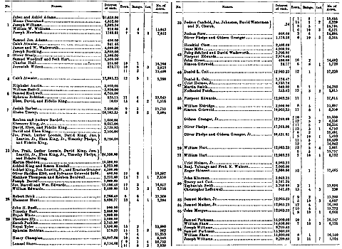
Go to top of this page
This web page and the episode links (below) are still under construction
Spalding Saga:
intro | 01 | 02 | 03 | 04 | 05 | 06 | 07 | 08 | 09 | 10 | 11 | 12
Spalding Studies "Research" | Spalding Research Project | Special Collections
"Home" | Bookshelf | Mormon Classics | Newspapers | History Vault
Last Revised: Mar. 20, 2006