THE JEFFERSON GAZETTE.
Vol. ? Jefferson, Ohio, May __ 1924. No. ?
THE INDIANS AND MOUND BUILDERS
OF ASHTABULA CO.
_________
Abstracts From a Talk By The Gazette Editor To The Students of
Ashtabula Harbor Schools, Delivered Thursday, May 15th, 1924.
One of the amazing things to me is the lack of knowledge by the boys and girls of this day of the pioneer history of their town, county and state. In a general way you are informed of the great events of the past century or so. I have appeared before a number of high schools in this county asking questions about Ashtabula county history, its place in the civic and military records of the nation, I get no answers. Few seniors can give me any definite description of the geography of the county in which they live. I am told that special attention is paid in Ashtabula Harbor schools to civics and to geography and I am very glad that is true. You have an unusual proportion of students here whose parents were foreign born and I have this to say of the majority of such boys and girls. As a rule the boy and girl of foreign birth or parentage who graduates from our high schools becomes a true American. Very frequently he is a better student, has a better command of English and has a deeper, knowledge of the genius of the country of his parents' adoption than those who trace their ancestry back to the days of the American Revolution. I am the fourteenth generation of American born, I am the fourth generation of my family holding continuous residence in old Ashtabula county. Naturally I am proud of the county. It hurts my pride to find so little is known, so little effort is made to teach you boys and girls the history of those men and women who, have made this county great agriculturally, great industrially and great in the social service of the state and nation.
This lecture, to be effective, should be a series of lectures, for one cannot elaborate upon any single phase of early Ashtabula county history in an hour. To-day I am to tell you something of the assumptions and known facts of occupation of this section of the state by earlier races.
I wonder how many of you know that almost within sight of this school building there was once a mound -- a burial mound, erected by a race of people, concerning whom we have but scant knowledge, and that all along Ashtabula river once were, and possibly are now, evidences of the work of the mound builders and their successors, the American Indian? It would pay you to take a day or two just to hunt over some of the territory I shall describe to you to find these places, and another day to travel in swift automobiles to other sections of the county, there to visit the mounds and Indian camps.
It is probable that the first white man who viewed the clay cliffs of old Lake Erie off Ashtabula was Robert ,Chevalier de la Salle, who, with a crew about thirty men, Father Henipin and three monks, sailed westward over Lake Erie in the little 45 ton schooner, the Griffin, in 1679. In those early days there was a rumor that this section was inhabited by fierce savages. No records are in existence of any white man's visit to Ashtabula until the latter part of the eighteenth century.
When the early settlers came here about 1801, the bones of two men were found in the creek valley, face downward, each clasping the barrel of a flint lock musket. Who they were or why they came or how they died no one will ever know.
Thomas Hamilton built the first cabin near the mouth of the river in l801 and he was helped by Judge Austin. who settled Austinburg. Judge Austin was the first known white man to enter Ashtabula harbor in a boat. A fine old brick mansion, later used in the Under-Ground railway, still stands a little north of Austinburg, and every member of the class in American history should visit this old house and others of which I would tell you if the time permitted.
Matthew Hubbard, the first land owner in Ashtabula, came here in 1804, and found in the creek valley many Indians. They came and went, living peacefully and often exchanging peat for meal with Hubbard. Mr. Hubbard wrote a history of his experiences and tells of the last Indian in this township. Standing Stone, a Seneca, and his visit with a woman from his tribe, then located farther west, who passed through Ashtabula about 1810, stopping here because she knew Rev. Joseph Badger, who lived in a hut near where the Catholic church on Lake street now stands. Rev. Badger was the first missionary to the Western Reserve. I have seven letters which he wrote, which I have rescued from oblivion in a recent campaign of hunting through old papers in the old attics and forgotten places in the county.
When the war of 1812 opened Standing Stone, like every other Indian save one, in Orwell, named "Jim, the Injun," disappeared. They went to Sandusky and joined the British in attacking the settlers and threatened to retard the advance of civilization in these sections for another score of years.
Mr. Hubbard tells of receiving fresh meat from young Amic, son of Amic the Chippewa chief, who lived at Wayne. Amic was killed in the battle of Sandusky -- a battle in which he and the Massauguans of Wayne and the rest of the Indians in this county took part against their old friends and neighbors. Joshua R. Giddings, later the great abolitionist, took part in that same battle.
I delight to delve in the old records and find out things about our early history. Only yesterday in the files of the Ashtabula Sentinel of 1858, I found several letters from Quintus F. Atkins, who came to Ashtabula county in 1802 and who went with Rev. Joseph Badger in l806 down the Grand or Geaugah river to Painesville and then up the lake to Sandusky as a missionary. In the party traveled Amic, his two wives and his two sons. These Indians lived on the St. Mary's in Michigan and spent the spring of each year in Ashtabula county making sugar. Mr. Atkins is my authority for this story.
Amic and Atkins had known each other for four years and were friends until the War of 1812. Atkins says Amic was a fine and trustworthy Indian. One time he came to Atkins' cabin in Morgan township, having broken the spring of his rifle. He could not get it fixed short of Pittsburgh, so he asked Atkins to loan him a rifle in receipt for a ham of venison every week until the Indian would get his own rifle repaired. Atkins says every week but one for two months a ham of venison was left at his cabin. [At the end] of the week that was missed, two hams were left and the rifle returned. It seems that Amic and his sons had been in Pittsburg the week the ham was not paid. Amic gave back the rifle to Atkins and said "Cowlatch, ressisting," which meant in Chippewa, "Good, very good."
Atkins tells of the repeated favors done him and other settlers by Amic, [and that] Amic was very careful not to cross Ashtabula creek or trespass on the lands of the tribes east of the river. On the long sail up the lakes Amic used an elk skin canoe with a blanket sail. In the story appears other Chippewa words, such as "chemung" for canoe. I have heard the Canadian Chippewas use the same word but it sounded more like "geman."
Another expression was "Kiteh gawmink wabutk debicot," meaning "We will reach the lake by tomorrow night." "Notin, webacch" meaning plenty wind presently.
The salutation of Amic on meeting a friend was "Sayah," My Indians always said "Que-que," or "quayquay," which was merely a general friendly salutation. I have heard it and made it hundreds of times on the blue lakes and the swift rivers and dark forests of the northland.
Amic had two wives, his squaw wife, who did the work and his "lady wife," whose father was an Englishman. The son of the lady wife was Pokawah, a surly, untrustworthy chap who came, to an end by way of a rope in Cleveland in 1812 for murder. Another Indian friend of Atkins who travelled with Amic was Conoshawa, and a son of the squaw wife, whom Atkins described as a very fine Indian,
Two Masauguan Indians who lived in Wayne were Mukwah, the bear, and Powqueih.
Now, I am going to tell you a secret. The other day in Wayne I saw an Indian telescope much like the one I am showing you, on it was inscribed the picture of a rudely drawn beaver. Amic often camped in Wayne. While not a Massauguan, he was a sort of overchief. Atkins says that Amic means "The Beaver," and I have no doubt that this particular little stone implement used by the hunter to spy game more readily belonged to Amic, the beaver, the great Chippewa chief, who after 12 years of friendship with the whites went over to the British and joined in fighting Ashtabula county white men at Sandusky. .Amic was killed by a soldier named Rice, at whom Amic had shot. Mr. Atkins himself was in this fight against his old Indian friend.
Before we recount more of the Ashtabula county Indians and leave this immediate vicinity I want you know of the old mounds. Plum point, within sight of this building was a mound. It was a burial mound and only a few months ago when the Pennsylvania raiway removed the point to make room for its great ore docks many skeletans were found.
It is probabie that this mound was not built by Indians any more than were the great cemeteries found in Ashtabula and Conneaut, or the earth forts, traces of which existed within my own life time in Chestnut Grove cemetery and across the gulf and in Hubbard Run. I am not able to definitely state but I think a certain odd appearing hill of earth in the valley of Hubbard Run is a mound. It is partially the work of nature and the work of human hands. See it you can find this partlcular spot. Then write to me at Jefferson what you think of it. The early settlers of Ashtabula have gone on record that where the east side cemetery is there were over 1000 graves when they came here, laid out with some evidence of mathematical skill. A few graves were opened and in some were found skulls and jaw bones of men whose size dwarfed the men who found the graves. The graves were not those of the Indian of the last or the previous century. The Indians who were here in the early nineteenth century know nothing of the origin of the grave yards or the mounds. Their legends did not fit in with those ancient places.
Rev. Joseph Badger reported that there was a well marked mound near his old home on Lake street and deseribes the place as have others of this period. A very interesting and authentic story can be found in the old Ashtabula county history published in 1878. Every school should have one of these old volumes. The stories they tell are not only instructive but highly entertaining and inspiring.
The old settlers likewise tell of mounds in Saybrook and of a place where there were about thirty circular depressions adjoining. These may have been a village and the depressions may have been store houses or food or supplies.
Along the creeks and rivers, especially along Ashtabula creek, Mills creek and Giddings creek in Jefferson are still depressions in which the Indians would hide waiting for game to pass, when the eagle winged arrow with its barb of flint was driven home.
I suppose all of you have seen flint arrow heads. How many of you have ever found one; while walking along the creeks or the fields? Have you any idea how they were made?
For centuries arrowheads and flints were an article of commerce in this vicinity. Artisans used to pass along the portages and trails from distant tribes coming here to trade their wares for furs. Flints such as were made into knives, spears, drills, and arrow heads are not native stone. Most of the local heads came from a great ledge of flint in Licking county, Ohio. Some of the finer pieces came from the Rocky Mountains. There are still old stone age quarries to be found. The Licking flint is not hard to flake when it first comes from the quarry. The artisan would take a chip about the size of the implement he wanted to make, protect one hand with a buckskin cover, take the prong of a buck horn for a small pry in the other hand and finding the line of cleavage press on the flint until it broke, a small piece at a time into the implement he desired. It would take you or me hours to do this, but only a few years ago a California Indian gave an exhibition of arrow work, making fine pieces in ten or fifteen minutes.
I have seen arrow heads ranging in size from half an inch of agate up to spear heads several inches long. I have about fifty fine specimens, a few of which I have with me, if you care to see them. The Indians your great grandfathers knew, if they lived here, seldom used stone tipped arrows, but had old flint lock muskets. I saw an old flint lock a few days ago in an attic in an old house in Rome. There is another hanging on the wall of the Miller house in Austinburg which Capt. Miller (91 years old) remembers seeing used to shoot squirrels.
There are thousands upon thousands of arrow heads, spears, knives and other early Indian and stone age implements in this county.
Here is a skinning stone. This was made by patient abrasion against stone. It was used by the aborigine to skin animals. He also had stone axes, and stone war clubs, stone pestles, stone rolling pins, stone ornaments, beads, stones with which he played games and a peculiar stone, which I am now showing you that has two holes drilled in it. Few people know what this is for but an old soldier -- one of the students of early men in this county told me its use. It was to aid the hunter in better seeing his game or prey. I hold it to my eye and everything except a small circle is excluded from vision. What is in that circle stands out very clearly. These stores were primitive sort of telescope or field glass -- without the aid of magnifying. These holes were made by flint drills -- flint pieces about four inches long, tapering with sharp edges, which were whirled, either on a stick or in the hand of the worker until the hole was made. I saw four of these drills a few days ago in the Orcutt Ward house in Wayne, picked up on the farm.
Wayne and the Pymatuning valley is rich in Indian and mound builder lore and evidence.
In the Porter Miner house last week at Wayne I saw many Indian and mound builder, or stoneman evidences. The best was a regular stone sledge hammer that none but a giant could have carried very long or very far. It must have weighed ten pounds. It was wedge shaped with a groove into which was fitted a forged club and the stone lashed to it with green rawhide and then dried and held firmly. A blow from it would have split the skull of a mammoth.
These stone weapons were not the weapons of the immediate ancestors of the Indians who were here in 1800. The were the tools of a vanished race, probably the race whose graves I have told you about, who made the mounds in Wayne and other places.
It is probable that a war-like race came into the county and drove the mound builders or stone men from the field, or massacred them. The old forts at Wayne, in Ashtabula, in Windsor hollow and at Conneaut probably were made by these invaders who made the forts to hold the territory they invaded.
In southwest Wayne is such a fort as the invaders built. You can see the ditch and earthwork ridge even yet. I saw it two years ago with Mr. Louth of Ashtabula. A half mile east of Wick station in Wayne, in the Pymatuning swamp is a real mound. It rises like an island from the swamp, once a deep morass. It will pay you to visit this place and the others as well. The top of the mound is like an inverted bowl. The mound builders lived in this bowl, defended by the swamp and the creek. The center shows that once there was a fire, or many fires there, while on the north side are depressions, which probably are graves. Mr. Louth and I dug into one two years ago and at three feet the sound was hollow. We came upon some charcoal, which was evidence that there was a grave below. Not having permission to trespass there we hastily refilled the hole and later received permission to dig, but for some reason have never opened the grave. In many places in Wayne township are small mounds and old camps. Am Indian grave yard lies south about a mile on the east side of the creek. Many of the Massauguan Indians died of small pox about 1810 and for that reason no one has dared to investigate their burial spots.
I have visited several of the mounds and old forts in this county, but there are many evidences that have been plowed under or have been obliterated in other ways, or have not been observed at all.
In the early day] settlers in Wayne found two depressions several feet deep, lined with stone like a well which bore evidences of having been store houses. Other places were found where stones were laid in a circular form and charcoal found on them, as it used in a religious ceremony, or possibly as a general camp fire or community center.
Some early finds were made of pottery but I have never chanced upon any Ashtabula county pottery.
In Windsor hollow on the west side about a quarter mile south and east of the old covered bridge an interesting fortification, the earthen work still prominent. Here must have been a camp or stronghold of early Indians or possibly mound builders.
The sight is on a promontory, high above the valley, Phelps creek with precipitous banks guards two sides and a small creek, about 10 feet wide protects the southern side. In the early days this was a swift running stream, its waters tumbling down and leaping out over the wall of the valley into the creek some thirty feet below -- even now in the spring there is a beautiful waterfall, the largest one I know anything about in Ashtabula county. The approach to this old fastness is guarded by a double row of embankment, and probably was topped by stones or logs. Many broad flat stones appear on the ground behind the mud walls, which some day were the ceremonial or mere resting places of the aborigines of Windsor.
When the first white men came to Windsor there were some 400 Indians of a peaceable but shiftless disposition, hunting and trapping along the creek and along Geaugah river. Geaugah is the Indian word for Grand. I think it unfortunate that our one river in this county, known as Grand River has lost its Indian name of Geaugah, but the county to the west of us has appropriated the name as Geauga county. I call my camp in Austinburg Camp Geaugah in honor of the old name and I often watch the river at evening and dream of one hundred and more years ago when my great grandfather, John Babcock, of Orwell, used to paddle his dugout up and down the stream. He was a hunter and a trapper, keeping a record of his catches, and numbering among them 499 deer. I have a package of old certificates given him back in the early 1820's by the county of Ashtabula for wolf bounties. He got $4 per scalp. I have about 60 certificates of various pioneers in the county who were paid. One man killed 7 wolves and the bounty was almost a year's wages in those days.
I have framed one of the certificates given my great grandfather and underneath it a certificate given "Jim, the Injun" for killing a wolf. Jim was the last Indian in this county. He disappeared mysteriously one day after starting into the forest threatening, to kill my great grandfather. Great grandfather came back alive but he had nothing to say about "Jim, the Injun."
My great grandfather, Ebenezer K. Lamson, a revolutionary soldier, and his family were responsible in a way for opening one of the roads in the western part of the county. They reached Harpersfield and could not get through to Windsor. Word was sent and the settlers at Windsor started for Harpersfield and cut the brush so the wagon could get through the forest to Windsor. There were many Indians in Windsor when they got there, but all of them left when the war of 1812 broke out. Windsor lands were great hunting and camping grounds and every farm lad has found old arrows, spears, knives and other stone tools and weapons. As much as I have been over the fields I have found but one arrowhead myself, but have seen others more fortunate pick them up just ahead of me several times.
There are mounds in Harpersfield, but I do not know anything about them. Monroe claims mounds, so does Conneaut.
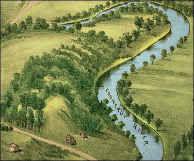
In the early days settlers in Conneaut found a number of mounds. On the west side along the creek there was a great burial ground. It is said there were about 3000 graves there, laid out in some design and like the cemetery at Ashtabula the bones of the adults were exceptionally large,
In the valley of the creek near the old bridge is a hill, partly the result of water wearing away and partly man's work. I have seen the hill from a distance and noted its natural adaptation to defense. It was called Fort Hill in 1812 by the settlers and when the British fleet appeared off Conneaut and fired a few rounds at the Fort on the bank of the lake the inhabitants of Conneaut retired to this old Fort Hill expecting to be massacred by the Indians who were supposed to be on the British fleet. A few years ago canon ball were found on the site of the old fort. Those few shots were the only shots ever fired upon Ashtabula county soil with hostile intent. A mound was known fifty years ago on the east side in Conneaut.
One of the most interesting stories arising from the old burial plot at Conneaut was the probable origin of the Book of Mormon.
A pioneer minister, Rev. Spaulding, in about 1812 wrote a manuscript [dealing] with the Lost Tribes of Israel. [He] told that he found the manuscript in one of the old graves at Conneaut. Later he travelled through the wilderness to Pittsburg and found a printer and tried to get his manuscript published. The printer did not enthuse and put the old tale away in a desk. A few years later it was uncovered by Sidney Rigdon, a preacher from Kirtland, Ohio, who had been prophesying that a great revelation was about to be made the chosen people at Kirtland. Rigdon conspired with Smith, father of Mormonism, to find the manuscript, which Smith did, and reported the find to have been in the form of copper plates. Rigdon went back to Kirtland with the fulfillment of the prophesy and from this scheme and the old Spaulding fraud may have come, and probably did come, the formation of the present great Mormon church of Utah.
There are but three Indian names in this county, Ashtabula, Conneaut and Pymatuning.
This county was a great hunting ground. It abounded in game but there are no records of Indian warfare in this county either of tribes against tribes or Indiana and whites. The county was neutral ground for decades. The dividing line between the great Algonquin and the greater Iroquois nations was Ashtabula creek pronounced in Algonquin "Hash-tah-buh-lah." Conneaut is an Iroquois word. While it is disputed the general opinion is that both words means the same thing, "river of many fish."
The Algonquin nation included many tribes, Ottawas, Eries, Wyandottes, Senecas, and practically all Indians along the shores of Lake Erie, Lake Michigan and Lake Huron. The Iroquois were the powerful Six Nations of New York. The story runs that the Iroquois practically annihilated the Eries following an athletic contest at Buffalo about 1650 and that the victors established Ashtabula creek as the line beyond which no Algonquin should travel eastward. The old feud between Algonquin and Iroquois is still in existence. I have been with the Indians in Canada several seasons and had an Algonquin chief at one time for my guide. He I told me of a wall or rock not far from where we were paddling one day where in the war between the two nations of Indians the farthest advance to the north had been pictured on the rocks and was still in evidence.
I hope you boys and girls will have found this talk sufficiently interesting, so that you will want to know more about your county. I would like to tell you of the old homes used for stations along the Underground Railway, and the story of Ashtabula County and the John Brown raid on Harper's Ferry but that would mean another hour. I would like to tell you of the great men and women of the early days and tell you of some of my own in interesting finds of historical papers. A series of lectures might well be given by some one capable in every school in the county -- the old county of Ashtabula, which gained its name in a most peculiar way.
When Moses Cleaveland and his surveyors for the Western Reserve came here in 1796 Mr. Cleaveland, wanted name this county in honor of his daughter, Mary Esther, and I save for a peculiar incident the fact that the wine ran out too quickly -- you would now be going to school in the county of Mary Esther, instead of the county bearing the Indian name of "Hash-tah-buh-lah." Moses Cleaveland told his surveyors that if they would agree to name the county Mary Esther he would provide them with four quarts of wine. They agreed to this and Cleveland produced the wine which all drank with zest. But the wine was not sufficient and it did not last but the river kept its course and the water flowed clear and bright, long before the days the [-------] or the sewer, or the ship yards or the harbor, through a valley crowned with maples and pines, and the surveyors declared that while Mary Esther right be a pretty name for a pretty girl it was not a name to bring into the rough forests and the wilderness the kind of men and the kind of women needed to populate the county. And so Mary. Esther was forgotten and the word "Ashtabula" was remembered and will be remembered so long as you tell your children and they tell their children the story of the greatness of its men and its women of the early days.
And. now we will close this long lecture with the Chippewa farewell again from the letters of Mr. Atkins, a few words in Chippewa that you may well remember, "Neechee, niconnes" -- Comrade, friend, good bye.
E. C. Lampson.
Note: Mr. Lampson's description of the "Indian telescope" leaves out the fact that some of the American tribes also used stones with holes drilled in them as "seer stones." The user could indeed peer through the two holes in such a stone to block extraneous things from his line of sight while out hunting -- but the same user could also unfocus his eyes, so as to create the illusion of the two holes converging into one. While scrutinizing this illusion the "seer" might claim a sort of psychic "second sight" and attempt to see things not open to normal human eyesight. Solomon Spalding describes a seer stone in his "Oberlin manuscript." But his magical stone was not of the Indian variety, with holes drilled into it.
|